Umbrail Pass
| Umbrail Pass | |
|---|---|
 Umbrail pass through Val Müstair | |
| Elevation | 2,501 m (8,205 ft) |
| Traversed by | road |
| Location | Italy–Switzerland border |
| Range | Alps |
| Coordinates | 46°32′35″N 10°26′02″E / 46.54306°N 10.43389°ECoordinates: 46°32′35″N 10°26′02″E / 46.54306°N 10.43389°E |
 Umbrail Pass Location of Umbrail Pass | |
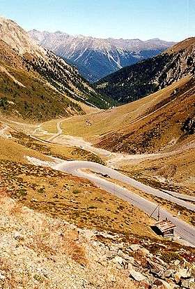
Umbrail Pass (el. 2,501 metres (8,205 ft)) is a high mountain pass on the Swiss-Italian border connecting Santa Maria in Val Müstair with Bormio in the Adda valley. On the Italian side, it connects to the Stelvio Pass road. It is currently the highest paved road in Switzerland.
The sign at the top of the pass gives its altitude as 2,503 meters above sea level, but the reference level for Swiss altitude measurements has changed since the sign was erected, leaving 2,501 meters as the correct value according to current methods.
The pass is named after the "Piz Umbrail", a nearby mountain peak.
The road is entirely asphalted since 2015. The last unpaved section was a 1.5 km stretch on the Swiss side between altitudes 1883m and 2012m. During the 2017 Giro d'Italia, Umbrail Pass was reached during the stage from Rovetta to Bormio.
See also
External links

- Profile on climbbybike.com
- Pictures from a crossing in August 2010 (in Romanian)
- Cycling up to the Umbrailpass: data, profile, map, photos and description