Stein, Limburg
| Stein | |||
|---|---|---|---|
| Municipality | |||
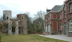 Stein castle | |||
| |||
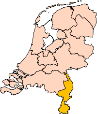
.svg.png) Location in Limburg | |||
| Coordinates: 50°58′N 5°46′E / 50.967°N 5.767°ECoordinates: 50°58′N 5°46′E / 50.967°N 5.767°E | |||
| Country | Netherlands | ||
| Province | Limburg | ||
| Government[1] | |||
| • Body | Municipal council | ||
| • Mayor | Marion Leurs-Mordang (PvdA) | ||
| Area[2] | |||
| • Total | 22.62 km2 (8.73 sq mi) | ||
| • Land | 21.15 km2 (8.17 sq mi) | ||
| • Water | 1.47 km2 (0.57 sq mi) | ||
| Elevation[3] | 61 m (200 ft) | ||
| Population (August 2017)[4] | |||
| • Total | 25,031 | ||
| • Density | 1,183/km2 (3,060/sq mi) | ||
| Demonym(s) | Steindenaar, Steinder | ||
| Time zone | UTC+1 (CET) | ||
| • Summer (DST) | UTC+2 (CEST) | ||
| Postcode | 6129, 6170–6171, 6180–6181 | ||
| Area code | 046 | ||
| Website |
www | ||


Stein (![]()
The municipality of Stein makes part of the region of South Limburg and lies between the city of Geleen in the east and Beek in the southeast, and lies furthermore west of interchange Kerensheide and the chemical industries of Chemelot. To the west lies the Belgian border, across the Meuse river. In comparison to other cities and villages in the area, Stein is fairly big. It is also the capital city of the municipality with the same name. It has i.a. three Roman Catholic churches, an abandoned mediaeval castle, and a port to the Juliana Canal which used to be the second largest inland port in all of Europe.
On 29 October 2009, the shopping mall of Stein suffered a severe fire. As a result of the calamity, the town subsequently lost 40 shops, 2 banks, 1 restaurant and 6 houses. The adjacent, iconic, 11-story apartment building 'De Stevel', remained intact.
Population centres
- Berg aan de Maas (Berg)
- Catsop (Katsep)
- Elsloo (Aelse)
- Maasband (Maasbendj)
- Meers (Meas)
- Nattenhoven (Nattenoave)
- Stein (Stein)
- Urmond (Uermend, Wermend)
(Local language in parentheses.)

Dutch topographic map of the municipality of Stein, June 2015
See also
References
- ↑ "College" [Board] (in Dutch). Gemeente Stein. Retrieved 29 November 2013.
- ↑ "Kerncijfers wijken en buurten" [Key figures for neighbourhoods]. CBS Statline (in Dutch). CBS. 2 July 2013. Retrieved 12 March 2014.
- ↑ "Postcodetool for 6171KP". Actueel Hoogtebestand Nederland (in Dutch). Het Waterschapshuis. Retrieved 29 November 2013.
- ↑ "Bevolkingsontwikkeling; regio per maand" [Population growth; regions per month]. CBS Statline (in Dutch). CBS. 27 October 2017. Retrieved 27 October 2017.
External links

- Official website
Places adjacent to Stein, Limburg | ||||||||||
|---|---|---|---|---|---|---|---|---|---|---|
| ||||||||||