Sittard-Geleen
| Sittard-Geleen Zittert-Gelaen | ||
|---|---|---|
| Municipality | ||
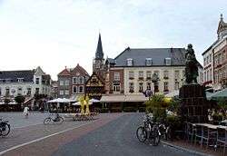 Sittard market square | ||
| ||
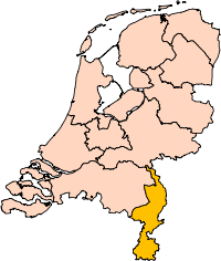
.svg.png) Location in Limburg | ||
| Coordinates: 51°0′N 5°52′E / 51.000°N 5.867°ECoordinates: 51°0′N 5°52′E / 51.000°N 5.867°E | ||
| Country | Netherlands | |
| Province | Limburg | |
| Established | 1 January 2001[1] | |
| Government[2] | ||
| • Body | Municipal council | |
| • Mayor | Sjraar Cox (PvdA) | |
| Area[3] | ||
| • Municipality | 80.53 km2 (31.09 sq mi) | |
| • Land | 79.02 km2 (30.51 sq mi) | |
| • Water | 1.51 km2 (0.58 sq mi) | |
| Elevation[4] | 47 m (154 ft) | |
| Highest elevation | 100 m (300 ft) | |
| Population (Municipality, August 2017; Urban and Metro, May 2014)[5][6] | ||
| • Municipality | 93,086 | |
| • Density | 1,178/km2 (3,050/sq mi) | |
| • Urban | 135,255 | |
| • Metro | 148,217 | |
| Time zone | UTC+1 (CET) | |
| • Summer (DST) | UTC+2 (CEST) | |
| Postcode | 6120–6167 | |
| Area code | 046 | |
| Website |
www | |


Sittard-Geleen (Dutch pronunciation: [ˌsɪtɑrt xəˈleːn] (![]()
The combined municipality has approximately 96,000 inhabitants (2007) and is thus the second most populated municipality in Limburg (after Maastricht with 125,000 inhabitants). Since the 2006 municipal elections, the city has been governed by a coalition of PvdA (Labour), GroenLinks (Green) and the local party GOB.
The highway connecting the centres of Sittard and Geleen, the Rijkswegboulevard, has been rebuilt to be a main route for cycling and walking. The cycling and walking provision is both generous and continuous. Side road junctions, or crossroads, are made 'subordinate'. The carriageways have been narrowed to one 3m lane in each direction. Parking places have been made, in small groups, at the side of the carriageways. These are made to be 'not easy to use for larger vehicles' and so the road centre is marked as a place for delivery vehicles to stop. Information supplied by the highway engineers: Büro für Stadt und Verkehr (BSV), Aachen, Germany.
To the west, Sittard-Geleen borders on Belgium, while to the east, it borders on Germany.
Population centres
Born, Broeksittard, Buchten, Einighausen, Geleen, Graetheide, Grevenbicht, Guttecoven, Holtum, Limbricht, Munstergeleen, Windraak, Obbicht, Papenhoven, Schipperskerk and Sittard.
Topography

Dutch Topographic map of the municipality of Sittard-Geleen, 2013.
References
- ↑ "Gemeentelijke indeling op 1 januari 2001" [Municipal divisions on 1 January 2001]. cbs.nl (in Dutch). CBS. Retrieved 12 October 2013.
- ↑ "Burgemeester Sjraar Cox" [Mayor Sjraar Cox] (in Dutch). Gemeente Sittard-Geleen. Archived from the original on 15 October 2013. Retrieved 12 October 2013.
- ↑ "Kerncijfers wijken en buurten" [Key figures for neighbourhoods]. CBS Statline (in Dutch). CBS. 2 July 2013. Retrieved 12 March 2014.
- ↑ "Postcodetool for 6131LB". Actueel Hoogtebestand Nederland (in Dutch). Het Waterschapshuis. Retrieved 12 October 2013.
- ↑ "Bevolkingsontwikkeling; regio per maand" [Population growth; regions per month]. CBS Statline (in Dutch). CBS. 27 October 2017. Retrieved 27 October 2017.
- ↑ "Bevolkingsontwikkeling; regio per maand" [Population growth; regions per month]. CBS Statline (in Dutch). CBS. 26 June 2014. Retrieved 24 July 2014.
- ↑ Geleen in isolation: [ɣəˈleːn].
External links

- Official website
Places adjacent to Sittard-Geleen | |
|---|---|
| Authority control |
|---|