Peel en Maas
| Peel en Maas | |
|---|---|
| Municipality | |
 | |
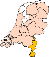
 Location in Limburg | |
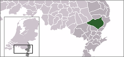
| Coordinates: 51°20′N 5°59′E / 51.333°N 5.983°ECoordinates: 51°20′N 5°59′E / 51.333°N 5.983°E | |
| Country | Netherlands |
| Province | Limburg |
| Established | 1 January 2010[1] |
| Government[2] | |
| • Body | Municipal council |
| • Mayor | Wilma Delissen-van Tongerlo (VVD) |
| Area[3] | |
| • Total | 161.35 km2 (62.30 sq mi) |
| • Land | 159.44 km2 (61.56 sq mi) |
| • Water | 1.91 km2 (0.74 sq mi) |
| Elevation[4] | 34 m (112 ft) |
| Population (August 2017)[5] | |
| • Total | 43,309 |
| • Density | 272/km2 (700/sq mi) |
| Time zone | UTC+1 (CET) |
| • Summer (DST) | UTC+2 (CEST) |
| Postcode | 5768, 5980–5995 |
| Area code | 077 |
| Website |
www |
Peel en Maas has been a new municipality in the southeastern Netherlands since 1 January 2010. It is situated in the province of Limburg. The municipality is formed by the towns of Panningen, Helden, Kessel, Kessel-Eik, Maasbree, Baarlo, Beringe, Egchel, Grashoek, Koningslust, and Meijel. It has a population of more than 40.000 people from various backgrounds. There are Hollanders from the northern parts of the Netherlands, former migrant workers from Turkey and Morocco, and former refugees from Syria and Afghanistan. The municipality has several facilities such as a high school, public library, swimming pool, and a well connected public bus transport system.
Each town has its own characteristics. The municipality's official slogan is: "beleef de ruimte!" (experience the space!).
History
The towns are situated in the Dutch province of Limburg. This province was part of the southern Catholic parts of the Low Lands. The towns used to be under Belgian, German, and eventually Dutch rule. Each town has a strong local identity and there is a healthy rivalry during the annual carnaval festivities.
Sightseeing
The municipality has several noteworthy places to visit.
- To the right is the Maas river with a boulevard in the city of Kessel
- To the south is the Musschenberg and the Weerdbeemden natural reserve. Along this path is a former Roman street where Roman coins have been found.
- Castle the Keverberg (Kessel)
- Sint Antonius Windmill (Kessel)
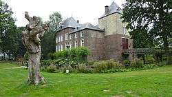
- Castle the Berckt (Baarlo)


Topography

Dutch Topographic map of the municipality of Peel en Maas, June 2015
References
- ↑ "Gemeentelijke indeling op 1 januari 2010" [Municipal divisions on 1 January 2010]. cbs.nl (in Dutch). CBS. Retrieved 18 November 2013.
- ↑ "Burgemeester" [Mayor] (in Dutch). Gemeente Peel en Maas. Retrieved 20 November 2013.
- ↑ "Kerncijfers wijken en buurten" [Key figures for neighbourhoods]. CBS Statline (in Dutch). CBS. 2 July 2013. Retrieved 12 March 2014.
- ↑ "Postcodetool for 5981CC". Actueel Hoogtebestand Nederland (in Dutch). Het Waterschapshuis. Retrieved 19 November 2013.
- ↑ "Bevolkingsontwikkeling; regio per maand" [Population growth; regions per month]. CBS Statline (in Dutch). CBS. 27 October 2017. Retrieved 27 October 2017.
External links
Places adjacent to Peel en Maas | ||||||||||
|---|---|---|---|---|---|---|---|---|---|---|
| ||||||||||