Starrucca, Pennsylvania
| Starrucca, Pennsylvania | |
|---|---|
| Borough | |
| Borough of Starrucca | |
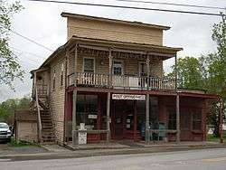 The Starrucca Post Office. | |
| Nickname(s): Wayne Borough,[1] Starucca[1] (both historical) | |
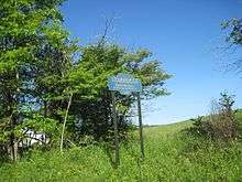
 Location in Wayne County and the U.S. state of Pennsylvania. | |
 Starrucca Location of Starrucca in Pennsylvania  Starrucca Starrucca (the US) | |
| Coordinates: 41°53′58″N 75°27′40″W / 41.89944°N 75.46111°WCoordinates: 41°53′58″N 75°27′40″W / 41.89944°N 75.46111°W | |
| Country | United States |
| State | Pennsylvania |
| US Congressional District | PA-10 |
| State Senatorial District | 20 |
| State House of Representatives District | 111 |
| County | Wayne |
| School District |
Susquehanna Community Region III |
| Settled | c. 1800[2] |
| Incorporated as "Wayne Borough" | 1853[1] |
| Renamed "Starucca Borough" | April 10, 1873[1] |
| Named for | Starrucca Creek[1] |
| Government | |
| • Type | Weak mayor-council |
| • Mayor | Mary Ann DeBalko[3] |
| • Borough Council[3] |
Council Members
|
| • US Representative | Tom Marino (R) |
| • State Senator | Lisa Baker (R) |
| • State Representative | Sandra Major (R) |
| Area[4] | |
| • Total | 8.98 sq mi (23.27 km2) |
| • Land | 8.91 sq mi (23.09 km2) |
| • Water | 0.07 sq mi (0.18 km2) |
| Elevation | 1,309[5] ft (399 m) |
| Population (2010) | |
| • Total | 173 |
| • Estimate (2016)[6] | 165 |
| • Density | 18.51/sq mi (7.15/km2) |
| Time zone | UTC-5 (Eastern (EST)) |
| • Summer (DST) | UTC-4 (Eastern Daylight (EDT)) |
| ZIP code |
De jure 18462[7] De facto 18462 18465[8] (Thompson) 18847[8] (Susquehanna) |
| Area code(s) | 570 (Exchange: 727) |
| GNIS feature IDs |
1188422[5][9] (Place) 1215688[9] (Borough) |
| FIPS code | 42-73784[10] |
| Waterways | Mach Pond,[11] Shadigee Creek, Starrucca Creek |
Starrucca (/ˈstrʌkə/ STRUK-ə) is a borough in Wayne County, Pennsylvania. The borough's population was 173 at the time of the 2010 United States Census.[12]
History
The historic Stone Arch Bridge was added to the National Register of Historic Places on January 1, 1979, and was delisted on May 8, 1986,[13] after being demolished.
Geography
Starrucca is located at 41°53′58″N 75°27′40″W / 41.89944°N 75.46111°W (41.574214, -75.255966).[14] According to the United States Census Bureau, Starrucca has a total area of 8.985 sq mi (23.27 km2), of which 8.915 sq mi (23.09 km2) is land and 0.070 sq mi (0.18 km2), or 0.77%, is water.[15]
Demographics
| Historical population | |||
|---|---|---|---|
| Census | Pop. | %± | |
| 1860 | 400 | — | |
| 1870 | 476 | 19.0% | |
| 1880 | 535 | 12.4% | |
| 1890 | 431 | −19.4% | |
| 1900 | 404 | −6.3% | |
| 1910 | 381 | −5.7% | |
| 1920 | 397 | 4.2% | |
| 1930 | 351 | −11.6% | |
| 1940 | 340 | −3.1% | |
| 1950 | 326 | −4.1% | |
| 1960 | 330 | 1.2% | |
| 1970 | 292 | −11.5% | |
| 1980 | 216 | −26.0% | |
| 1990 | 199 | −7.9% | |
| 2000 | 216 | 8.5% | |
| 2010 | 173 | −19.9% | |
| Est. 2016 | 165 | [6] | −4.6% |
| Sources:[16][17] | |||
As of the Census of 2010, there were 173 people, 75 households, and 52 families in Starrucca. The borough's population density was 19.4 people per square mile (7.49/km2), and there were 126 housing units at an average density of 14.0/sq mi (5.41/km2). The racial makeup of the populace was 96.0% White, 1.7% African American, 0.0% Native American, 0.6% Asian, 0.0% Pacific Islander, 0.6% of other races, and 1.2% of two or more races. Hispanics and Latinos of all races made up 4.0% of the population.[15][16]
69.3% of Starrucca's households were families, 56.0% were headed by a heterosexual married couple (Pennsylvania did not allow same-sex marriage until May 20, 2014, after the 2010 Census had been completed), and 20.0% included children under the age of 18. 6.7% of households were headed by a female householder with no husband present, 6.7% by a male householder with no wife present, and 30.7% consisted of non-families. 28.0% of all households were made up of individuals, and 12.0% consisted of a person 65 years of age or older living alone. The average household size was 2.31 and the average family size was 2.69.[16]
Starrucca's age distribution was 20.2% under the age of 18, 2.3% between the ages of 18 and 24, 20.2% between 25 and 44, 38.7% between 45 and 64, and 18.5% 65 years of age or older. The population's median age was 49.3 years. For every 100 females, there were 130 males. For every 100 females age 18 and over, there were 130 males in the same age range.[16]
According to American Community Survey (ACS) estimates, the median income for a household in Starrucca in 2013 was $47,500, and the median income for a family was $67,500. Males had a median income of $35,625, while females had a median income of $28,125. The per capita income for the borough was $24,535. 2.6% of families and 24.3% of people were below the Census Bureau's poverty thresholds (different from the federally defined poverty guidelines), including 0.0% of those under age 18 and 8.3% of those age 65 or over.[18][19]
According to self-reported ancestry figures recorded by the ACS, the five largest ancestral groups in Starrucca in 2013 were Germans (28.8%), English (19.9%), Poles (10.5%), Irish (9.9%), and Dutch (6.8%). Those reporting American ancestry made up 2.6% of the population.[20]
References
- 1 2 3 4 5 Ham, Thomas J. (1995) [1905 - 1907]. Fluhr, George J., ed. The Nomenclature of Wayne: A History of Wayne County, PA (Compiled from articles originally published in the Honesdale Citizen.). Honesdale, PA: Wayne County Historical Society (published 2003). p. 4.
- ↑ Mathews, Alfred (1886). History of Wayne, Pike, and Monroe Counties, Pennsylvania. Philadelphia: R.T. Peck & Company. p. 718. Retrieved 19 June 2015.
- 1 2 "Municipal Index" (PDF). Wayne County Planning Commission/GIS. WordPress. 2011. Archived from the original (PDF) on 3 December 2014. Retrieved 19 June 2015.
- ↑ "2016 U.S. Gazetteer Files". United States Census Bureau. Retrieved Aug 14, 2017.
- 1 2 "Starrucca". Geographic Names Information System. United States Geological Survey. 2 August 1979. Retrieved 19 June 2015.
- 1 2 "Population and Housing Unit Estimates". Retrieved June 9, 2017.
- ↑ "Look up a ZIP CodeTM". USPS.COM. USPS. 2015. Retrieved 19 June 2015.
- 1 2 "US Postal Code Boundaries". Google. Google, Inc. 3 February 2014. Retrieved 21 June 2015.
- 1 2 "Borough of Starrucca". Geographic Names Information System. United States Geological Survey. 30 August 1990. Retrieved 19 June 2015.
- ↑ U.S. Census Bureau. Census 2000. "Census Demographic Profiles, Starrucca Borough" (PDF). CenStats Databases. Retrieved 2009-01-31.
- ↑ "Mach Pond". Geographic Names Information System. United States Geological Survey. 2 August 1979. Retrieved 19 June 2015.
- ↑ "2010 Census Interactive Population Search". Census.gov. U.S. Department of Commerce. 2010. Retrieved 19 June 2015.
- ↑ National Park Service (2010-07-09). "National Register Information System". National Register of Historic Places. National Park Service.
- ↑ "US Gazetteer files: 2010, 2000, and 1990". United States Census Bureau. 2011-02-12. Retrieved 2011-04-23.
- 1 2 2014 Census National Places Gazetteer File for Pennsylvania (Report). U.S. Department of Commerce. 2014. Retrieved 29 June 2015.
- 1 2 3 4 Profile of General Population and Housing Characteristics: 2010 Demographic Profile Data for Starrucca, Pennsylvania (Report). U.S. Department of Commerce. 2010. Retrieved 19 June 2015.
- ↑ Census of Population and Housing (Report). U.S. Department of Commerce. 2010. Retrieved 20 June 2015.
- ↑ SELECTED ECONOMIC CHARACTERISTICS 2009-2013 American Community Survey 5-Year Estimates for Starrucca, Pennsylvania (Report). U.S. Department of Commerce. 2013. Retrieved 19 June 2015.
- ↑ OCCUPATION BY SEX AND MEDIAN EARNINGS IN THE PAST 12 MONTHS (IN 2013 INFLATION-ADJUSTED DOLLARS) FOR THE CIVILIAN EMPLOYED POPULATION 16 YEARS AND OVER 2009-2013 American Community Survey 5-Year Estimates for Starrucca, Pennsylvania (Report). U.S. Department of Commerce. 2013. Retrieved 19 June 2015.
- ↑ SELECTED SOCIAL CHARACTERISTICS IN THE UNITED STATES 2009-2013 American Community Survey 5-Year Estimates for Starrucca, Pennsylvania (Report). U.S. Department of Commerce. 2013. Retrieved 29 June 2015.
External links
Municipalities and communities of Wayne County, Pennsylvania, United States | ||
|---|---|---|
| Boroughs | 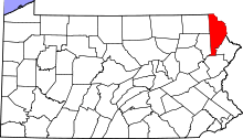 | |
| Townships | ||
| CDPs | ||
| Unincorporated communities | ||