Mount Pleasant Township, Wayne County, Pennsylvania
| Mount Pleasant, Pennsylvania | |
|---|---|
| Second-class township | |
| Township of Mount Pleasant | |
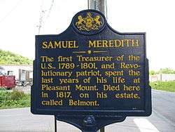 A sign in Belmont Corners commemorating Samuel Meredith, the second Treasurer of the United States (despite what the sign says), and one of the more famous former residents of Mount Pleasant. | |
 Location in Wayne County and the state of Pennsylvania. | |
| Country | United States |
| State | Pennsylvania |
| US Congressional District | PA-10 |
| State Senatorial District | 20 |
| State House of Representatives District | 111 |
| County | Wayne |
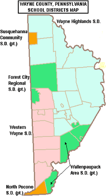
| School District |
Forest City Regional Regions V & IV |
| Settled | June 1789[1] |
| Incorporated |
March 21, 1798 (original township of Wayne County) |
| Founded by | Samuel Stanton[1] |
| Government | |
| • Type | Board of Supervisors |
| • Board of Supervisors[2] |
Supervisors
|
| • US Representative | Tom Marino (R) |
| • State Senator | Lisa Baker (R) |
| • State Representative | Sandra Major (R) |
| Area[3] | |
| • Total | 57.57 sq mi (149.11 km2) |
| • Land | 56.46 sq mi (146.22 km2) |
| • Water | 1.12 sq mi (2.89 km2) |
| Elevation | 1,427 ft (434.9 m) |
| Population (2010) | 1,357 |
| • Estimate (2016)[4] | 1,322 |
| • Density | 23.42/sq mi (9.04/km2) |
| Time zone | UTC-5 (Eastern (EST)) |
| • Summer (DST) | UTC-4 (Eastern Daylight (EDT)) |
| Area code(s) | 570 |
| GNIS feature ID | 1217224[5] |
| FIPS code | 42-127-51872[6] |
Mount Pleasant is a second-class township in Wayne County, Pennsylvania. The township's population was 1,357 at the time of the 2010 United States Census.[7]
Geography
According to the United States Census Bureau, the township has a total area of 57.6 square miles (149.2 km²), of which, 56.5 square miles (146 km²) of it is land and 1.1 square miles (3 km²) of it (1.91%) is water.
Communities
The following villages are located in Mount Pleasant Township:
Demographics
| Historical population | |||
|---|---|---|---|
| Census | Pop. | %± | |
| 2010 | 1,357 | — | |
| Est. 2016 | 1,322 | [4] | −2.6% |
| U.S. Decennial Census[14] | |||
As of the census of 2010, there were 1,357 people, 565 households, and 383 families residing in the township. The population density was 24 people per square mile (9.3/km²). There were 831 housing units at an average density of 14.7/sq mi (5.7/km²). The racial makeup of the township was 97.1% White, 0.7% African American, 0.2% American Indian, 0.9% Asian, 0.5% from other races, and 0.6% from two or more races. Hispanic or Latino of any race were 2.8% of the population.
There were 565 households out of which 20.9% had children under the age of 18 living with them, 55.6% were married couples living together, 7.4% had a female householder with no husband present, and 32.2% were non-families. 26.4% of all households were made up of individuals and 12% had someone living alone who was 65 years of age or older. The average household size was 2.40 and the average family size was 2.91.
In the township the population was spread out with 19.7% under the age of 18, 59.4% from 18 to 64, and 20.9% who were 65 years of age or older. The median age was 48.6 years.
The median income for a household in the township was $53,424, and the median income for a family was $63,100. Males had a median income of $42,250 versus $29,038 for females. The per capita income for the township was $25,987. About 1.5% of families and 1.8% of the population were below the poverty line, including 2.2% of those under age 18 and 1.7% of those age 65 or over.
Education
Forest City Regional School District is a Preschool-12th grade public school district serving residents of Mount Pleasant Township.
References
- 1 2 Goodrich, Phineas G. (1992) [1880]. History of Wayne County. Baltimore: Gateway Press, Inc. p. 188.
- ↑ "Municipal Index" (PDF). Wayne County Planning Commission/GIS. WordPress. 2011. Archived from the original (PDF) on 3 December 2014. Retrieved 22 November 2014.
- ↑ "2016 U.S. Gazetteer Files". United States Census Bureau. Retrieved Aug 14, 2017.
- 1 2 "Population and Housing Unit Estimates". Retrieved June 9, 2017.
- ↑ "Township of Mount Pleasant". Geographic Names Information System. United States Geological Survey. 1 December 1989. Retrieved 20 November 2014.
- ↑ U.S. Census Bureau. Census 2000. "Census Demographic Profiles, Mount Pleasant Township" (PDF). CenStats Databases. Retrieved 2009-01-31.
- ↑ "American FactFinder". United States Census Bureau. Retrieved 2011-05-14.
- 1 2 3 4 5 6 7 "MOUNT PLEASANT: SECOND CLASS TOWNSHIP MAP" (PDF). Pennsylvania Department of Transportation. Commonwealth of Pennsylvania. 23 September 2013. Retrieved 20 November 2014.
- 1 2 "Belmont Corner". Geographic Names Information System. United States Geological Survey. 2 August 1979. Retrieved 20 November 2014.
- ↑ "Cascade". Geographic Names Information System. United States Geological Survey. 30 August 1990. Retrieved 20 November 2014.
- ↑ "Niagara". Geographic Names Information System. United States Geological Survey. 1 December 1989. Retrieved 20 November 2014.
- ↑ "Rudes Corner". Geographic Names Information System. United States Geological Survey. 2 August 1979. Retrieved 20 November 2014.
- ↑ "Whites Valley". Geographic Names Information System. United States Geological Survey. 2 August 1979. Retrieved 20 November 2014.
- ↑ "Census of Population and Housing". Census.gov. Retrieved June 4, 2016.
Municipalities and communities of Wayne County, Pennsylvania, United States | ||
|---|---|---|
| Boroughs | 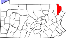 | |
| Townships | ||
| CDPs | ||
| Unincorporated communities | ||