St Francis Bay
| St Francis Bay St Francisbaai | |
|---|---|
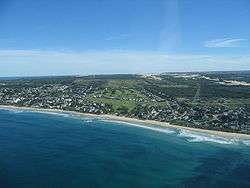 Aerial photo of St Francis Bay | |
 St Francis Bay  St Francis Bay St Francis Bay (South Africa)  St Francis Bay St Francis Bay (Africa) | |
| Coordinates: 34°09′43″S 24°49′48″E / 34.162°S 24.830°ECoordinates: 34°09′43″S 24°49′48″E / 34.162°S 24.830°E | |
| Country | South Africa |
| Province | Eastern Cape |
| District | Sarah Baartman |
| Municipality | Kouga |
| Area[1] | |
| • Total | 10.04 km2 (3.88 sq mi) |
| Population (2011)[1] | |
| • Total | 4,933 |
| • Density | 490/km2 (1,300/sq mi) |
| Racial makeup (2011)[1] | |
| • Black African | 51.2% |
| • Coloured | 21.7% |
| • Indian/Asian | 0.2% |
| • White | 26.1% |
| • Other | 0.8% |
| First languages (2011)[1] | |
| • Xhosa | 39.4% |
| • Afrikaans | 32.7% |
| • English | 21.7% |
| • Zulu | 1.2% |
| • Other | 4.9% |
| Time zone | UTC+2 (SAST) |
| Postal code (street) | 6312 |
| PO box | 6312 |
St Francis Bay (Afrikaans: St Francisbaai) is a holiday village in Sarah Baartman District Municipality in the Eastern Cape province of South Africa, roughly one hour’s drive from Port Elizabeth.
On 11 November 2012 a fire destroyed 76 homes in the mostly thatched roofed town.[2]
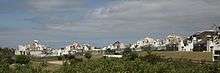
The building style of the village includes white painted houses with black roofs (either thatch or tiled roofs) on the canals or around the golf course, or a Mediterranean building style in Santareme and Port St Francis. The Kromme River is navigable for 10 km upstream, and is linked to the St Francis canals system.
Whales can be spotted in the Bay from May to late October and dolphins can be seen daily on their way back and forth between the bays of Cape St Francis and Jeffrey’s Bay. The Cape clawless otter is also ever present, frolicking in the waves and rock pools around Port St Francis and at Otters Landing. Bird life is abundant with over 200 species recorded in the area including the rare African oystercatcher and fish eagle.
Port St Francis includes a commercial and recreational harbour, built to host the squid industry freezing vessels, as well as a small harbour resort village. It lies in a sheltered nook of the bay and provides a safe anchorage for the boats, pleasure craft, and oceangoing yachts. St Francis Field is an airpark close to the Port that caters for those who wish to fly in.
Cape St Francis, a rustic fishing village, sits adjacent to St Francis Bay. Popular for surfing at Seal Point, its beautiful stretch of beach and the historic lighthouse, built in 1878. Walking trails wind along the rocky coast, through the Irma Booysen Floral Reserve, and along the Cape St Francis point links it to the village of St Francis Bay.
Cape St Francis is 8 km from Thyspunt, the preferred site for South Africa's next nuclear power station.[3][4]
References
- 1 2 3 4 "Main Place St Francis Bay". Census 2011.
- ↑ "76 homes destroyed by St Francis Bay fire". News24. 12 November 2012.
- ↑ "Nuclear 1 - Transmission - Thyspunt". Retrieved 3 June 2015.
- ↑ "Thyspunt is a prime candidate for a nuclear site – Dr Kelvin Kemm". Retrieved 3 June 2015.
External links
| Wikimedia Commons has media related to St Francis Bay. |

- Residents Association
- St Francis Bay
- St Francis Bay Webcam
Municipalities and communities of Sarah Baartman District Municipality, Eastern Cape | ||
|---|---|---|
District seat: Port Elizabeth | ||
| Blue Crane Route | .svg.png) | |
| Dr Beyers Naudé | ||
| Kouga | ||
| Kou-Kamma | ||
| Makana | ||
| Ndlambe | ||
| Sunday's River Valley | ||