Middleton, Eastern Cape
| Middleton | |
|---|---|
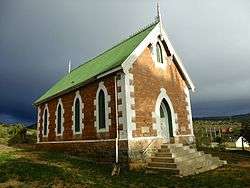 Old church in Middleton, built 1903 | |
 Middleton  Middleton Middleton (South Africa)  Middleton Middleton (Africa) | |
| Coordinates: 32°56′56″S 25°48′58″E / 32.949°S 25.816°ECoordinates: 32°56′56″S 25°48′58″E / 32.949°S 25.816°E | |
| Country | South Africa |
| Province | Eastern Cape |
| District | Sarah Baartman |
| Municipality | Blue Crane Route |
| Time zone | UTC+2 (SAST) |
| PO box | 5810 |
Middleton is a hamlet in the Eastern Cape province of South Africa, situated on the banks of the Fish River,[1] off the N10 road and about 30km south of Cookhouse.[2] It was established in 1879 as a train stop, and the station (which has since been converted into a pub) was one of the first buildings to be erected.[1] The hamlet is currently in the ownership of the Noupoort Christian Care Center.[3]
References
- 1 2 "Sleepy Eastern Cape dorp seeks new owner". IOL News. Retrieved 18 August 2014.
- ↑ "Middleton". Artefacts. Retrieved 18 August 2014.
- ↑ "Reintergration: CIARA Middleton". Noupoort Christian Care Center. Archived from the original on 3 February 2014. Retrieved 18 August 2014.
Municipalities and communities of Sarah Baartman District Municipality, Eastern Cape | ||
|---|---|---|
District seat: Port Elizabeth | ||
| Blue Crane Route | .svg.png) | |
| Dr Beyers Naudé | ||
| Kouga | ||
| Kou-Kamma | ||
| Makana | ||
| Ndlambe | ||
| Sunday's River Valley | ||
This article is issued from
Wikipedia.
The text is licensed under Creative Commons - Attribution - Sharealike.
Additional terms may apply for the media files.