St. Charles, Kentucky
| St. Charles, Kentucky | |
|---|---|
| City | |
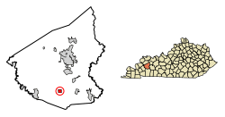 Location of St. Charles in Hopkins County, Kentucky. | |
| Coordinates: 37°11′3″N 87°33′19″W / 37.18417°N 87.55528°WCoordinates: 37°11′3″N 87°33′19″W / 37.18417°N 87.55528°W | |
| Country | United States |
| State | Kentucky |
| County | Hopkins |
| Area | |
| • Total | 1.00 sq mi (2.59 km2) |
| • Land | 0.99 sq mi (2.57 km2) |
| • Water | 0.008 sq mi (0.02 km2) |
| Elevation | 440 ft (134 m) |
| Population (2010) | |
| • Total | 277 |
| • Estimate (2016)[1] | 269 |
| • Density | 279/sq mi (107.7/km2) |
| Time zone | UTC-6 (Central (CST)) |
| • Summer (DST) | UTC-5 (CDT) |
| FIPS code | 21-67710 |
| GNIS feature ID | 0502599 |
St. Charles is a home rule-class city in Hopkins County, Kentucky, United States. The population was 277 at the 2010 U.S. Census.[2]
History
St. Charles was settled as a coal mining camp in 1872 on land purchased from J.I.D. Woodruff by the Saint Bernard Mining Company. In 1873, the post office was established under the name "Woodruff", but when the city was incorporated in 1874, the name was changed to "St. Charles" for now unknown reasons.[3]
A small store stood near a deep spot in the creek that was used as a fording place by all who had occasion to cross it. A farm was nearby and The Christian Privilege Meeting House, a focal point of worship and one of the first Christian churches in Hopkins County was to the north. From these humble beginnings eventually grew the town of St. Charles. Because of the creek ford and the store, the travel through the area grew and a small settlement was established. Many railroad workers settled in the area when the lines were built. That settlement became known as Woodruff—named for C. B. Woodruff, a farmer who owned a great deal of land in the area. Many Union soldiers made their homes in Woodruff after the Civil War. The War caused big problems for the little town. Groups of guerillas roamed the area, killed two prominent citizens and caused a great deal more unrest in the small community. The coal mining boom came to Woodruff in 1872 when a mine was opened in the town by the St. Bernard Coal Company. That's when the town name was changed from Woodruff to St. Charles.
Two opposing stories exist about the origin of the new name of the town. One says that it was named for Charles Woodruff, who owned all the land sold to the coal company. The other says the founder of the coal company had a son named Charles and wanted the town named after him. The establishment of a store and houses by the coal company for their employees divided the town into an old and new section. The new section consisted of the coal company's ventures while the old section was made up of businesses owned by independent merchants. The dual personality of St. Charles resulted in duplicates of everything from schools to social clubs. With the passage of time businesses came and went, the mines eventually shut down and St. Charles became the sleepy little town it is today.
Geography
St. Charles is located in southern Hopkins County at 37°11′3″N 87°33′19″W / 37.18417°N 87.55528°W (37.184139, -87.555164).[4] U.S. Route 62 passes through the southern part of the community, leading east 6 miles (10 km) to Nortonville and west 8 miles (13 km) to Dawson Springs.
According to the United States Census Bureau, St. Charles has a total area of 1.0 square mile (2.6 km2), of which 0.01 square miles (0.02 km2), or 0.70%, are water.[2]
Demographics
| Historical population | |||
|---|---|---|---|
| Census | Pop. | %± | |
| 1880 | 356 | — | |
| 1890 | 449 | 26.1% | |
| 1900 | 753 | 67.7% | |
| 1910 | 660 | −12.4% | |
| 1920 | 604 | −8.5% | |
| 1930 | 634 | 5.0% | |
| 1940 | 536 | −15.5% | |
| 1950 | 534 | −0.4% | |
| 1960 | 421 | −21.2% | |
| 1970 | 373 | −11.4% | |
| 1980 | 405 | 8.6% | |
| 1990 | 316 | −22.0% | |
| 2000 | 309 | −2.2% | |
| 2010 | 277 | −10.4% | |
| Est. 2016 | 269 | [1] | −2.9% |
| U.S. Decennial Census[5] | |||
As of the census[6] of 2000, there were 309 people, 120 households, and 90 families residing in the city. The population density was 538.0 people per square mile (209.3/km²). There were 133 housing units at an average density of 231.6 per square mile (90.1/km²). The racial makeup of the city was 98.71% White, 0.32% Pacific Islander, and 0.97% from two or more races.
There were 120 households out of which 37.5% had children under the age of 18 living with them, 59.2% were married couples living together, 10.8% had a female householder with no husband present, and 24.2% were non-families. 21.7% of all households were made up of individuals and 10.0% had someone living alone who was 65 years of age or older. The average household size was 2.58 and the average family size was 3.02.
In the city, the population was spread out with 25.9% under the age of 18, 6.5% from 18 to 24, 32.7% from 25 to 44, 22.0% from 45 to 64, and 12.9% who were 65 years of age or older. The median age was 36 years. For every 100 females, there were 98.1 males. For every 100 females age 18 and over, there were 102.7 males.
The median income for a household in the city was $20,469, and the median income for a family was $20,000. Males had a median income of $21,875 versus $13,750 for females. The per capita income for the city was $10,230. About 26.1% of families and 29.2% of the population were below the poverty line, including 40.6% of those under the age of eighteen and 24.4% of those sixty five or over.
References
- 1 2 "Population and Housing Unit Estimates". Retrieved June 9, 2017.
- 1 2 "Geographic Identifiers: 2010 Demographic Profile Data (G001): St. Charles city, Kentucky". American Factfinder. U.S. Census Bureau. Retrieved July 10, 2017.
- ↑ Rennick, Robert. Kentucky Place Names, p. 260. University Press of Kentucky (Lexington), 1987. Accessed 4 October 2013.
- ↑ "US Gazetteer files: 2010, 2000, and 1990". United States Census Bureau. 2011-02-12. Retrieved 2011-04-23.
- ↑ "Census of Population and Housing". Census.gov. Retrieved June 4, 2015.
- ↑ "American FactFinder". United States Census Bureau. Retrieved 2008-01-31.
Municipalities and communities of Hopkins County, Kentucky, United States | ||
|---|---|---|
| Cities | 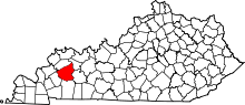 | |
| CDP | ||
| Other unincorporated communities | ||
| Footnotes | ‡This populated place also has portions in an adjacent county or counties | |