Nebo, Kentucky
| Nebo, Kentucky | |
|---|---|
| City | |
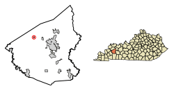 Location of Nebo in Hopkins County, Kentucky. | |
| Coordinates: 37°23′4″N 87°38′29″W / 37.38444°N 87.64139°WCoordinates: 37°23′4″N 87°38′29″W / 37.38444°N 87.64139°W | |
| Country | United States |
| State | Kentucky |
| County | Hopkins |
| Incorporated | 1861 |
| Named for | Mount Nebo[1] |
| Area | |
| • Total | 0.25 sq mi (0.64 km2) |
| • Land | 0.25 sq mi (0.64 km2) |
| • Water | 0.0 sq mi (0.0 km2) |
| Elevation | 404 ft (123 m) |
| Population (2010) | |
| • Total | 236 |
| • Estimate (2016)[2] | 229 |
| • Density | 952/sq mi (367.7/km2) |
| Time zone | UTC-6 (Central (CST)) |
| • Summer (DST) | UTC-5 (CDT) |
| ZIP code | 42441 |
| Area code(s) | 270 & 364 |
| FIPS code | 21-55092 |
| GNIS feature ID | 0499206 |
Nebo is a home rule-class city in Hopkins County, Kentucky, in the United States. The population was 236 as of the 2010 census.[3]
Geography
Nebo is located in northwestern Hopkins County at 37°23′4″N 87°38′29″W / 37.38444°N 87.64139°W (37.384425, -87.641429).[4] U.S. Route 41A passes through the center of Nebo, leading east 9 miles (14 km) to Madisonville, the county seat, and west 7 miles (11 km) to Providence.
According to the United States Census Bureau, Nebo has a total area of 0.25 square miles (0.64 km2), all land.[3]
Demographics
| Historical population | |||
|---|---|---|---|
| Census | Pop. | %± | |
| 1880 | 174 | — | |
| 1890 | 183 | 5.2% | |
| 1900 | 237 | 29.5% | |
| 1910 | 298 | 25.7% | |
| 1920 | 265 | −11.1% | |
| 1930 | 329 | 24.2% | |
| 1940 | 272 | −17.3% | |
| 1950 | 282 | 3.7% | |
| 1960 | 338 | 19.9% | |
| 1970 | 274 | −18.9% | |
| 1980 | 269 | −1.8% | |
| 1990 | 227 | −15.6% | |
| 2000 | 220 | −3.1% | |
| 2010 | 236 | 7.3% | |
| Est. 2016 | 229 | [2] | −3.0% |
| U.S. Decennial Census[5] | |||
As of the census[6] of 2000, there were 220 people, 84 households, and 67 families residing in the city. The population density was 877.9 people per square mile (339.8/km²). There were 93 housing units at an average density of 371.1 per square mile (143.6/km²). The racial makeup of the city was 100.00% White.
There were 84 households out of which 34.5% had children under the age of 18 living with them, 59.5% were married couples living together, 11.9% had a female householder with no husband present, and 20.2% were non-families. 19.0% of all households were made up of individuals and 10.7% had someone living alone who was 65 years of age or older. The average household size was 2.62 and the average family size was 2.97.
In the city, the population was spread out with 25.5% under the age of 18, 13.2% from 18 to 24, 26.4% from 25 to 44, 24.1% from 45 to 64, and 10.9% who were 65 years of age or older. The median age was 36 years. For every 100 females, there were 101.8 males. For every 100 females age 18 and over, there were 97.6 males.
The median income for a household in the city was $31,667, and the median income for a family was $36,250. Males had a median income of $26,458 versus $21,250 for females. The per capita income for the city was $16,117. None of the families and 3.9% of the population were living below the poverty line, including no under eighteens and 19.4% of those over 64.
References
- ↑ "Dictionary of Places: Nebo". Encyclopedia of Kentucky. New York, New York: Somerset Publishers. 1987. ISBN 0-403-09981-1.
- 1 2 "Population and Housing Unit Estimates". Retrieved June 9, 2017.
- 1 2 "Geographic Identifiers: 2010 Demographic Profile Data (G001): Madisonville city, Kentucky". American Factfinder. U.S. Census Bureau. Retrieved July 6, 2017.
- ↑ "US Gazetteer files: 2010, 2000, and 1990". United States Census Bureau. 2011-02-12. Retrieved 2011-04-23.
- ↑ "Census of Population and Housing". Census.gov. Retrieved June 4, 2015.
- ↑ "American FactFinder". United States Census Bureau. Retrieved 2008-01-31.
Municipalities and communities of Hopkins County, Kentucky, United States | ||
|---|---|---|
| Cities | 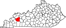 | |
| CDP | ||
| Other unincorporated communities | ||
| Footnotes | ‡This populated place also has portions in an adjacent county or counties | |