Charleston, Kentucky
| Charleston, Kentucky | |
|---|---|
| Unincorporated community | |
 Charleston  Charleston | |
| Coordinates: 37°13′29″N 87°40′19″W / 37.22472°N 87.67194°WCoordinates: 37°13′29″N 87°40′19″W / 37.22472°N 87.67194°W | |
| Country | United States |
| State | Kentucky |
| County | Hopkins |
| Elevation | 531 ft (162 m) |
| Time zone | UTC-6 (Central (CST)) |
| • Summer (DST) | UTC-5 (CST) |
| GNIS feature ID | 489364[1] |
Charleston is an unincorporated community in southwestern Hopkins County, Kentucky, United States.
According to legend, it was named for "Free Charles", a former slave, who kept a tavern there. A Charleston post office was in operation from 1855 to 1909.[2]
References
- ↑ U.S. Geological Survey Geographic Names Information System: Charleston, Kentucky
- ↑ Rennick, Robert M. (1987). Kentucky Place Names. University Press of Kentucky. p. 56. Retrieved 2013-04-28.
Municipalities and communities of Hopkins County, Kentucky, United States | ||
|---|---|---|
| Cities | 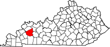 | |
| CDP | ||
| Other unincorporated communities | ||
| Footnotes | ‡This populated place also has portions in an adjacent county or counties | |
This article is issued from
Wikipedia.
The text is licensed under Creative Commons - Attribution - Sharealike.
Additional terms may apply for the media files.