Spelthorne Hundred
| Spelthorne | |
|---|---|
 | |
| Area | |
| • 1831 | 23,386 acres (94.64 km2)[1][2] |
| Population | |
| • 1831 | 15,212[3] |
| • 1881[4] | 33,460 |
| History | |
| • Created | in late Anglo Saxon England |
| Status | hundred |
| Subdivisions | |
| • Type |
Parishes containing manors, churchlands and commons. Henry VIII created the two royal parks in the eastern two parishes - Bushy Park and Hampton Court Park - and set up hunting rights and similar privileges across much of the hundred. By the 19th century all the commons were enclosed and only manor with its lands largely undivided was Hampton Court. |
Spelthorne was a hundred (dated subdivision) of the historic county of Middlesex, England. It contained these parishes and settlements[5] :
- Ashford
- East Bedfont
- The hamlet of Hatton
- Feltham
- Hampton
- The settlement of Hampton Hill developed in the 19th century
- Hampton Wick
- Hanworth
- Laleham
- Littleton since the 1970s contiguous with Shepperton
- The chapelry of Astleham/Aslam. In the 1930s replaced with the Queen Mary Reservoir.
- Shepperton
- Staines
- Stanwell
- The hamlet of Stanwell Moor, since the 20th century a village without a church
- Sunbury
- The hamlet of Upper Halliford, today a village, joined postally with Shepperton
- The hamlet of Charlton, joined postally with Shepperton
- Teddington
- Part of the neighbourhood of Fulwell, once a single-ownership estate, by consensus spreading south to around to its train station
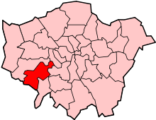
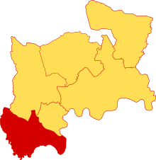
The present-day district of Spelthorne in Surrey amounts to about 59% of the hundred.[6][4] The eastern parts since 1965 form parts of the London boroughs of Hounslow and Richmond upon Thames.

Demography
A decennial table for each parish is published in the Victoria County History series. By 1891 the Hundred was legally moribund, having already been de facto moribund. The population of the north-eastern six parishes has been greater than the south-west seven since an unknowable point in time between the 1831 and 1841 censuses. A summary is:[4]
| Area name | Acreage | 1801 population | 1821 population | 1841 population | 1861 population | 1881 population | 1901 population |
|---|---|---|---|---|---|---|---|
| Seven parishes becoming in 1965 part of Surrey | 13,733 | 5604 | 6720 | 7915 | 9152 | 14520 | 20888 |
| Six parishes becoming in 1965 part of London | 9,653 | 4624 | 6697 | 8672 | 10288 | 18940 | 32280 |
| Total (Spelthorne Hundred) | 23,386 | 10288 | 13417 | 16587 | 19440 | 33460 | 53168 |
Relative to the county as a whole, the hundred (one of six) had 12.9% of its 181,320 acres. In 1801 it had 1.3% of the 818,129 people recorded as living in Middlesex; in 1901 it had 1.6% of the 3,585,323 people stated in the census to be living in the county (including in the County of London parts which once lay in Middlesex).[4]
See also
- TW postcode area, the centre-west bulk of which corresponds with Spelthorne Hundred. It adds Richmond, Brentford, Isleworth Hundred (or half-hundred) and Egham
- Spelthorne (UK Parliament constituency), a seat of the House of Commons since 1918 which was initially larger and is since 1945 smaller than the Hundred.
- Spelthorne, a second-tier local authority identical or near-identical in size to the Parliamentary seat's area.
References
- ↑ Great Britain Historical GIS / University of Portsmouth, Middlesex hundreds 1831 census population. Retrieved 2008-02-20.
- ↑ http://www.british-history.ac.uk/vch/middx/vol2/pp112-120
- ↑ http://www.visionofbritain.org.uk/unit/10216114/cube/TOT_POP
- 1 2 3 4 'Table of Acreage and populations, 1801-1901', in A History of the County of Middlesex: Volume 2, General ed. William Page (London, 1911), pp. 112-120. British History Online http://www.british-history.ac.uk/vch/middx/vol2/pp112-120 [accessed 24 May 2018].
- ↑ "Table Of Population 1801–1901". British History. Retrieved 19 January 2017.
- ↑ 13733 of 23386 acres in terms of the traditional areas (parishes); the bulk successor has negligibly diverged on its external boundaries since 1901.
Coordinates: 51°26′N 0°25′W / 51.43°N 0.41°W