Havelland (district)
| Havelland | |
|---|---|
| District | |
 | |
| Country |
|
| State | Brandenburg |
| Capital | Rathenow |
| Area | |
| • Total | 1,717 km2 (663 sq mi) |
| Population (31 December 2017)[1] | |
| • Total | 160,710 |
| • Density | 94/km2 (240/sq mi) |
| Time zone | UTC+01:00 (CET) |
| • Summer (DST) | UTC+02:00 (CEST) |
| Vehicle registration | HVL |
| Website | http://www.havelland.de |
brown = more than 45 m above sea level,
green = forests, mostly more than 45 m above sea level
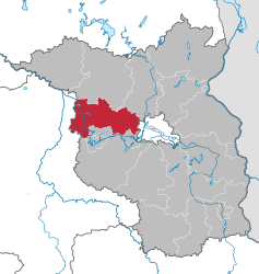
Havelland (German pronunciation: [ˈhaːfəlˌlant]) is a district or county in Brandenburg, Germany. It is bounded by (from the north and clockwise) the districts of Ostprignitz-Ruppin and Oberhavel, the city-state of Berlin, the district of Potsdam-Mittelmark, the city of Brandenburg and the state of Saxony-Anhalt (districts of Jerichower Land and Stendal).
History
The district was established in 1993 by merging the former districts of Nauen and Rathenow.
Demography
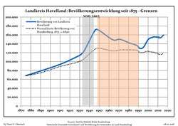 Development of Population since 1875 within the Current Boundaries (Blue Line: Population; Dotted Line: Comparison to Population Development of Brandenburg state)
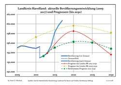 Recent Population Development and Projections (Population Development before Census 2011 (blue line); Recent Population Development according to the Census in Germany in 2011 (blue bordered line); Projection by the Brandenburg state for 2005-2030 (yellow line); Projection by the Brandenburg state for 2014-2030 (red line); Projection by the Bertelsmann Foundation for 2012-2030 (green line)
| Landkreis Havelland: Population development within the current boundaries (2017)[2] | ||||||||||||||||||||||||||||||||||||||||||||||||||||||||||||||||||||||||||||||||||||||||||||||||||||||||||||||||||||||||||||||||||||||
|---|---|---|---|---|---|---|---|---|---|---|---|---|---|---|---|---|---|---|---|---|---|---|---|---|---|---|---|---|---|---|---|---|---|---|---|---|---|---|---|---|---|---|---|---|---|---|---|---|---|---|---|---|---|---|---|---|---|---|---|---|---|---|---|---|---|---|---|---|---|---|---|---|---|---|---|---|---|---|---|---|---|---|---|---|---|---|---|---|---|---|---|---|---|---|---|---|---|---|---|---|---|---|---|---|---|---|---|---|---|---|---|---|---|---|---|---|---|---|---|---|---|---|---|---|---|---|---|---|---|---|---|---|---|---|
|
|
| ||||||||||||||||||||||||||||||||||||||||||||||||||||||||||||||||||||||||||||||||||||||||||||||||||||||||||||||||||||||||||||||||||||
Geography
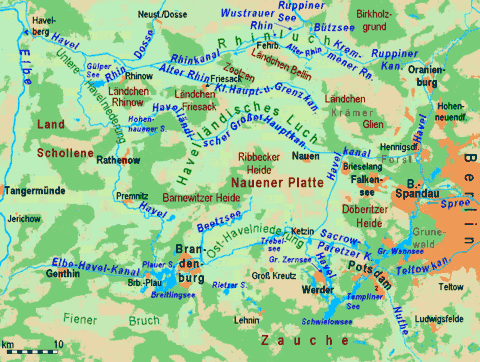
Geographically the Havelland refers to the land either side of the Havel river and the area surrounded by the large "U" bend in its course between the city of Berlin and its confluence with the Elbe river. The district mainly consists of the areas north of the Havel river.
Coat of arms
 |
The red eagle is the heraldic animal of Brandenburg. The head of the eagle is part of the coat of arms of Rathenow. The swan is often used as a symbol for the Havelland region. |
Towns and municipalities
| Amt-free towns | Ämter | |
|---|---|---|
|
|
1. Friesack 2. Nennhausen |
3. Rhinow |
| 1seat of the Amt; 2town | ||
References
- ↑ "Bevölkerung im Land Brandenburg nach amtsfreien Gemeinden, Ämtern und Gemeinden 31. Dezember 2017 (Fortgeschriebene amtliche Einwohnerzahlen auf Grundlage des Zensus 2011)". Amt für Statistik Berlin-Brandenburg (in German). 2018.
- ↑ Detailed data sources are to be found in the Wikimedia Commons.Population Projection Brandenburg at Wikimedia Commons
External links
| Wikimedia Commons has media related to Havelland. |
- Official website (German)
- tourist website (German, English)
| Urban districts | |
|---|---|
| Rural districts | |