South Central Siberia
South Central Siberia: This article deals with the geography of the region north of the point where Russia, China, Kazakhstan and Mongolia come together.
.svg.png)
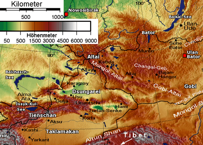
Kuznets Basin to the west and Minusinsk basin to the east.
Altai Republic to the south, Altai Krai northwest of that and Tuva to the southeast
The Four Corners
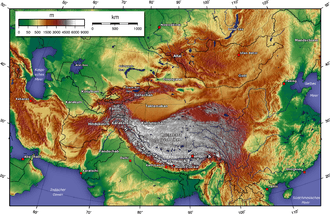
At approximately 49°8′8″N 87°33′46″E / 49.13556°N 87.56278°E, the borders of Russia, China, Mongolia and Kazakhstan form a ">-<" shape in the Altai Mountains. Mongolia and Kazakhstan are kept separate by a 40km stretch of the Sino-Russian border between the Altai Republic, a federal subject of Russia, and Altay Prefecture in the Xinjiang Uyghur Autonomous Region of China. To the east, Tavan Bogd Uul in Bayan-Ölgii Province, Mongolia, marks the end of the Sino-Russian border. To the west, is Kazakhstan's East Kazakhstan Province.
The Altai mountains on the Russian side of the border have been designated a UNESCO world heritage site.[1]
South: Altai Republic
At the top of the X is the Altai Republic (not to be confused with the Altai Krai to the northwest). It contains the central knot to the Altai Mountains. The area is very mountainous and still has few good roads. It was inhabited by various Turkic groups who gradually became the Altay people. As the surrounding steppes filled with Russians, many of the lowland Turks were Russified or retreated to the mountains. It only came under definitive Russian control in the 1860s. The M52 highway (Russia) runs northwest from here.
Northern mountain range: Abakans and Kuznetsk Alatau
North of the Altai Republic is a 400 km projection of forested mountains which bends slightly to the west at the tip. It is called the Abakan Range in the south and Kuznetsk Alatau in the north. North of its northern end is the town of Tomsk.
West: Kuznetsk Depression
The mountains look something like the right hand seen from the side. The hand proper and fingers are the Abakans and Kuznetsk Alatau and the thumb is the Salair Ridge which ends near Novosibirsk. Between the 'thumb' and the 'fingers' is the steppe of the Kuznetsk Depression, which contains the large Kuznetsk Basin coal fields. In the Soviet era this was the largest Russian coal field after the Donets Basin. The name (Kuznets=blacksmith) comes from the 'Blacksmith Tatars' or Shors, who were notable metal workers. The Russians reached the area as early as 1618. The Abakans, Kuznetsk Alatau and the Kuznetsk Basin form the Kemerovo Oblast with its mostly Russian population. The Tom River drains the basin and joins the Ob River north of Tomsk. The town of Novokuznetsk was founded in 1618
East: Minusinsk Depression
To the east, between the Kuznetsk Alatau and the Sayan Mountains, is the steppe of the Minusinsk Depression which is the core of Khakassia. The Yenisei River flows north through its center. The Abakan River flows from the base of the depression north and slightly east to the Yenisei at Abakan town, near where a (name?) river comes in from the east. Minusinsk town is a few miles east of Abakan. The Chulym River (Ob River) starts in the northwest corner of the depression, arcs into the Taiga north of the Alatau and joins the Ob River. East of the river is the southern tip of Krasnoyarsk Krai. This area was a centre of the Afanasevo culture, a suggested homeland for the Tocharians. Later it was the home of the Yenisei Kirghiz, who gave their name to the Kirgiz further south. The Khakas of Khakassia may be their descendants.
Southeast: Tuva
East of the Altai and southeast of Minusinsk is Tuva. Tuva is bounded on the south by the Tannu-Ola Mountains, which separate it from the Mongolian Great Lakes Depression, on the west by the Altai, on the northwest by the Western Sayans which separate it from the Minusinsk Depression, on the north by the Eastern Sayans and on the east by (name?) mountains on the Mongolian border.
The core area is the Tuva Depression, where Kyzyl is located, the capital city of the Tuva Republic. The Yenisei River flows west here and then breaks through the Western Sayans in a long narrow gorge which contains the Sayano-Shushenskaya Dam north of the Tuva border. Tuva is somewhat boot-shaped facing west. The shank of the boot is separated from the Tuva Depression by the (name?) mountains. Tuva was traditionally part of Mongolia, and only passed to the Soviet Union—Russia in the 20th century.
Surrounding area
To the north the land merges into the Siberian forests.
To the south it merges into the mountains along the former Sino-Soviet border. Dzungaria is directly to the south.
To the west is the agricultural steppe of the Altai Krai with its Russian population. Here the Katun River and the Biya River join to form the Ob River. Further west, between the Ob and Irtysh Rivers are the Baraba steppe in the north and the Kalunda Steppe in the south.
To the east, the Western and then Eastern Sayan Mountains extend east to the southern tip of Lake Baikal.
Also
Large Towns: From west to east: Novosibirsk is about 100 km northwest of the Salair 'thumb' on the Ob River; Tomsk is about 50 km north of the Kuznetsk Alatau; Krasnoyarsk is about 100 km north of the Minusinsk Depression on the Yenisei. Barnaul is on the steppe south of Novosibirsk.
The Trans-Siberian Railway runs from Novosibirsk to Krasnoyarsk.
Forest and Steppe: The area to the west is steppe or forest-steppe. The steppe curves around north of the Kuznetsk Alatau into the Minusinsk Depression. The land to the north and east is Taiga.
The Russians first entered the area about 1620. Seeking furs, they stayed in the forest area to the north. Massive peasant colonization of the steppe area only began after about 1860.
Related Articles: Altai-Sayan region to the east; Barabinsk Steppe to the west; Kanas Lake to the south in China; Great Lakes Depression to the southeast in Mongolia; Saylyugemsky National Park at south end of the Altai Republic; Shorsky National Park south of the Kuznetsk Basin; Denisova Cave archeological site on the border of the Altai Krai and Altai Republic; Ukok Plateau, steppe on the south side of the Altai Republic near Mongolia, home of the Pazyryk Culture; the Lykov family lived isolated in the mountains.
References
Relevant Literature
- Forsyth, James, "A History of the Peoples of Siberia", 1992.