Kuznetsk Alatau
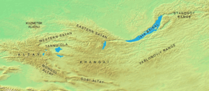

Coordinates: 54°8′N 88°45′E / 54.133°N 88.750°E Kuznetskiy Alatau (Russian: Кузнецкий Алатау) is a mountain range in South Siberia, Russia, between Kuznetsk Depression and Minusinsk Depression. Length: about 300 km., elevation: up to 2,178 metres (7,146 ft). It is part of the mountain system of Central Asia. See Geography of South-Central Siberia.
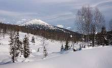
These mountains have smooth outline, rather steep western and gentle eastern slopes. The fir overwhelmingly predominates in the forest belt except for its upper part where, at the tree line (1300–1900 m), the pine becomes dominant. The highlands are occupied mostly by vast large-stoned screes, and also by patches of subalpine meadows and, on some southern mountain massifs, of bushy, lichen and moss tundras. The basin of the Kondoma River in Gornaya Shoriya is remarkable for the lime-tree woods which are thought to be the relics of a pre-Pleistocene nemoral vegetation of Siberia. All over the upland the forest openings are occupied by long forb forest meadows.[1]
The range is composed mainly of metamorphic rocks rich in iron, manganese, nephelines, and gold.
Aeroflot Flight 593 crashed in the Kuznetskiy Alatau mountain range in 1994.[2]
References
- ↑ "A geographic scetch, the text from Korshunov & Gorbunov (1995)".
- ↑ Learmount, David; Velovich, Alexander (27 April – 3 May 1994). "FDR backs A310 crash allegations". Flight International: 5. Archived from the original on 7 October 2016.
| Wikimedia Commons has media related to Kuznetsk Alatau. |