East Kazakhstan Region
| East Kazakhstan Region Шығыс Қазақстан облысы Восточно-Казахстанская область | ||
|---|---|---|
| Region | ||
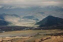 Bukhtarma river in East Kazakhstan | ||
| ||
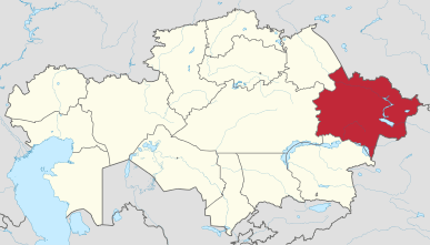 Map of Kazakhstan, location of East Kazakhstan Region highlighted | ||
| Coordinates: 49°57′N 82°37′E / 49.950°N 82.617°ECoordinates: 49°57′N 82°37′E / 49.950°N 82.617°E | ||
| Country |
| |
| Established | 1932 | |
| Capital | Oskemen | |
| Government | ||
| • Akim | Daniyal Akhmetov | |
| Area | ||
| • Total | 283,226 km2 (109,354 sq mi) | |
| Population (2013-02-01)[1] | ||
| • Total | 1,393,932 | |
| • Density | 4.9/km2 (13/sq mi) | |
| Time zone | UTC+6 (East) | |
| • Summer (DST) | UTC+6 (not observed) | |
| Postal codes | 070000 | |
| Area codes | +7 (722), +7 (723) | |
| ISO 3166 code | KZ-VOS | |
| Vehicle registration | 16, F, U | |
| Districts | 15 | |
| Cities | 10 | |
| Townships | 30 | |
| Villages | 870 | |
| Website |
akimvko | |
East Kazakhstan Region (Kazakh: Шығыс Қазақстан облысы, translit. Shyǵys Qazaqstan oblysy; Russian: Восточно-Казахстанская область, translit. Vostochno-Kazakhstanskaya oblast) is a region of Kazakhstan. It occupies the easternmost part of Kazakhstan, along both sides of the Irtysh River and Lake Zaysan. Its administrative center is Oskemen (also known as Ust-Kamenogorsk). The region borders Russia in the north and northeast and the People's Republic of China in the south and southeast. The easternmost point of the Oblast is within about 50 kilometres of the westernmost tip of Mongolia; however, Kazakhstan and Mongolia do not share a common border, the two countries being separated by a small part of Russia and China. East Kazakhstan Region borders the Kazakh regions of Pavlodar Region to the north west, Karaganda Region to the west, Almaty Region to the south, Russia's Altai Krai and Altai Republic to the north and China's Xinjiang Uyghur Autonomous Region to the east.[2] Population: 1,396,593 (2009 Census results);[3] 1,531,024 (1999 Census results).[3] 318,800 (as of 4/1/2011) live in the capital. The area has many Russians and Ukrainians; the capital itself has more of those two groups than Kazakhs themselves. The area is 283,300 square kilometers.
The region was created by the merger of two Soviet-era Kazakhstan oblasts: the old Vostochno-Kazakhstanskaya (East Kazakhstan) Oblast and Semipalatinsk Oblast.
Nature
The region occupies a very diverse range of geographic and climatic regions with the Altai Mountains in the east and the eastern margins of the Kazakh steppes in the west of the region.
Demographics
60,04% of the population is ethnic Kazakh and 35,11% is ethnic Russian.[4]
Administrative divisions
The region is administratively divided into fifteen districts and the cities of Oskemen (Ust-Kamenogorsk), Ayagoz, Kurchatov, Ridder, Semey (Semipalatinsk), and Zyryanovsk.[5]
- Abay District, with the administrative center in the selo of Karauyl;
- Ayagoz District, the town of Ayagoz;
- Beskaragay District, the selo of Beskaragay;
- Borodulikha District, the selo of Borodulikha;
- Glubokoye District, the settlement of Glubokoye;
- Katonkaragay District, the selo of Ulken Narym;
- Kokpekti District, the selo of Kokpekti;
- Kurshim District, the selo of Kurshim;
- Shemonaikha District, the town of Shemonaikha;
- Tarbagatay District, the selo of Aksuat;
- Ulan District, the settlement of Molodyozhny;
- Urzhar District, the selo of Urzhar;
- Zaysan District, the town of Zaysan;
- Zharma District, the selo of Kalbatau (Georgiyevka);
- Zyryan District, the town of Zyryanovsk.
* The following ten localities in East Kazakhstan Region have town status: Oskemen (Ust-Kamenogorsk), Ayagoz, Charsk (Shar), Kurchatov, Ridder, Semey (Semipalatinsk), Serebryansk, Shemonaikha, Zaysan, and Zyryanovsk.
Sport
The region sent a bandy team to the Spartakiade 2009 and finished third.[6]
See also
References
- ↑ Agency of statistics of the Republic of Kazakhstan: Численность населения Республики Казахстан по областям с началa 2013 года до 1 февраля 2013 года (russisch; Excel-Datei; 55 kB).
- ↑ https://primeminister.kz/enpage/article-88
- 1 2 "Население Республики Казахстан" (in Russian). Департамент социальной и демографической статистики. Retrieved 8 December 2013.
- ↑ ru:Восточно-Казахстанская область
- ↑ "Akimats of cities and districts". East Kazakhstan Region's Akimat. Retrieved 12 December 2012.
- ↑ "Команда Восточно-Казахстанской области". Archived from the original on 2014-06-10. Retrieved 2014-06-10.
External links
| Wikimedia Commons has media related to East Kazakhstan Region. |
Places adjacent to East Kazakhstan Region | ||||||||||
|---|---|---|---|---|---|---|---|---|---|---|
| ||||||||||
Capital: Oskemen | ||
| Districts |  | |
| Major cities | ||