South Carolina Highway 8
| ||||
|---|---|---|---|---|
 | ||||
| Route information | ||||
| Maintained by SCDOT | ||||
| Length | 43.93 mi[1] (70.70 km) | |||
| Existed | 1928 – present | |||
| Major junctions | ||||
| West end |
| |||
| East end |
| |||
| Location | ||||
| Counties | Greenville, Anderson, Pickens | |||
| Highway system | ||||
| ||||

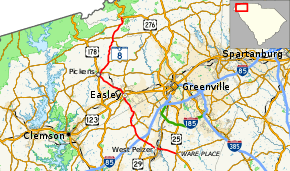
South Carolina Highway 8 (abbreviated S.C. Highway 8 or SC 8) is a primary state highway in the U.S. state of South Carolina. It runs from U.S. Route 276 (US 276) in northern Greenville County to US 25 and SC 418 in Ware Place. It runs physically north and south though it is signed as a west-east highway with its western terminus at US 276 and its eastern terminus at US 25/SC 418.
Route description
SC 8 begins in Ware Place at the junction of US 25 and SC 418. From here, it travels west for about four miles (6.4 km) when it crosses the Saluda River and enters the town of Pelzer in Anderson County. It meets SC 20 at the town limit of Pelzer and after crossing SC 20 it enters West Pelzer.[2]
After exiting West Pelzer, it runs northwest for two miles (3.2 km) and has an interchange with US 29. About one mile (1.6 km) past US 29, the highway has an interchange with Interstate 85 (I-85) at its exit 32. Another mile past this interchange, SC 8 intersects SC 81, which runs concurrent with SC 8 for two miles (3 km). SC 8 turns to the west and crosses SC 88 and winds its way to the western terminus of SC 86.[2]
Here, it turns to the northwest and crosses into Pickens County and runs toward Easley. Soon after entering the city limits of Easley, it meets SC 135 and overlaps it for one-half mile (0.80 km). SC 8 then turns to the northwest and crosses US 123, but has no access to the highway directly. After one mile (1.6 km), it intersects SC 93 just west of downtown Easley. From here, it is eight miles (13 km) to Pickens, and for this duration, the road is four-laned. In downtown Pickens, SC 8 meets SC 183 and overlaps it for a half-mile.[2]
SC 8 continues straight and runs toward Pumpkintown, along the way meeting the western terminus of SC 186 and the northern terminus of SC 135. In Pumpkintown, it crosses SC 288 and soon meets SC 11, which it has a concurrency with for about a half-mile. SC 8 then turns north and meets its end at US 276 in northern Greenville County.[2]
History
The first alignment of SC 8 ran from the Georgia state line through Anderson, Greenville, Greer, Spartanburg, Gaffney, and Blacksburg into North Carolina near Grover. This alignment connected directly to Georgia State Route 8 at the Georgia state line. In 1927, this became US 29, and SC 8 was put onto a completely different alignment, which was previously SC 13 (which was reused on former SC 17). With a few minor changes, this is today's SC 8.
Major intersections
| County | Location[3] | mi[1] | km | Destinations | Notes |
|---|---|---|---|---|---|
| Greenville | | 0.00 | 0.00 | ||
| Pickens | | 1.26 | 2.03 | Northern terminus of SC 11 concurrency | |
| | 1.85 | 2.98 | Southern terminus of SC 11 concurrency | ||
| | 5.54 | 8.92 | |||
| | 6.12 | 9.85 | Northern terminus of SC 135 | ||
| | 11.49 | 18.49 | Western terminus of SC 186 | ||
| Pickens | 14.41 | 23.19 | Northern terminus of SC 183 concurrency | ||
| 14.85 | 23.90 | Southern terminus of SC 183 concurrency | |||
| Easley | 21.79 | 35.07 | |||
| 23.00 | 37.01 | Northern terminus of SC 135 concurrency | |||
| 23.50 | 37.82 | Southern terminus of SC 135 concurrency | |||
| Anderson | | 27.48 | 44.22 | Western terminus of SC 86 | |
| | 30.84 | 49.63 | Eastern terminus of SC 88 | ||
| | 31.34 | 50.44 | Northern terminus of SC 81 concurrency | ||
| | 33.31 | 53.61 | Southern terminus of SC 81 concurrency | ||
| | 34.58– 34.73 | 55.65– 55.89 | I-85 exit 32 | ||
| | 35.92– 36.34 | 57.81– 58.48 | Grade-separated interchange with US 29 | ||
| Pelzer–West Pelzer line | 39.46 | 63.50 | |||
| Greenville | Ware Place | 43.93 | 70.70 | Western terminus of SC 418 | |
1.000 mi = 1.609 km; 1.000 km = 0.621 mi
| |||||
References
- 1 2 "Statewide Highways (shapefile)" (zip). South Carolina Department of Transportation. September 29, 2017. Retrieved December 8, 2017.
- 1 2 3 4 Google (January 24, 2018). "South Carolina Highway 8" (Map). Google Maps. Google. Retrieved January 24, 2018.
- ↑ Geography Division (2016). "South Carolina Governmental Unit Reference Map". United States Census Bureau. Retrieved January 29, 2017.
External links
| Wikimedia Commons has media related to South Carolina Highway 8. |