South Carolina Highway 20
| ||||
|---|---|---|---|---|
 | ||||
| Route information | ||||
| Maintained by SCDOT | ||||
| Length | 53.17 mi[1] (85.57 km) | |||
| Existed | 1922 – present | |||
| Major junctions | ||||
| West end |
| |||
| East end | Camperdown Way in Greenville | |||
| Location | ||||
| Counties | Abbeville, Anderson, Greenville | |||
| Highway system | ||||
| ||||

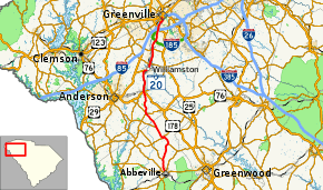
South Carolina Highway 20 (SC 20) is a primary state highway in the U.S. state of South Carolina. The highway connects the cities of Abbeville, Belton, Williamston and Greenville. The 53-mile-long (85 km) highway is signed as a west-east highway though it physically runs south-to-north.[2]
History
Established in 1922 as an original state highway, it traversed from the Georgia state line to SC 8 (Guess Street/Green Avenue) in Greenville; connecting McCormick, Abbeville, Due West, Honea Path, Belton, and Williamston. Between 1924-1925, SC 20 was extended north, along Green Avenue, to SC 2/SC 8 (Pendleton Street), replacing a section of SC 8; this would be the longest distance SC 20 ever traveled, reaching over 107 miles (172 km) in length.
In 1935, SC 20 was truncated at U.S. Route 29 (US 29, Anderson Highway) in Williamston; its old alignment becoming US 29. In 1936, all of SC 20 was fully paved. Around 1937, SC 20 was truncated to its current western terminus in Abbeville, its alignment to the state line replaced by SC 28. In 1956, SC 20 was rerouted between Due West and Belton, replacing SC 257 and some of SC 284; its old alignment, through Honea Path, was replaced by SC 184 and US 178. Also same year, SC 20 was extended back along its old alignment north to a rerouted US 29, just south of Greenville. In 1962, SC 20 was extended into downtown Greenville, along Grove Avenue, ending at US 25 (Augusta Road), replacing US 29 Business (US 29 Bus.). In 2000, SC 20 was extended to its current northern terminus at Falls Park Drive (formerly Camperdown Way) just shy of US 123, replacing part of US 25 Bus.[3][4][5][6][7][8]
Junction list
| County | Location | mi[2] | km | Destinations | Notes |
|---|---|---|---|---|---|
| Abbeville | Abbeville | 0.0 | 0.0 | ||
| 0.4 | 0.64 | ||||
| 0.6 | 0.97 | ||||
| 2.3 | 3.7 | ||||
| | 4.0 | 6.4 | |||
| | 10.0 | 16.1 | South end of SC 185 overlap | ||
| Due West | 12.4 | 20.0 | East end of SC 184 overlap | ||
| 12.8 | 20.6 | West end of SC 184 overlap | |||
| | 16.4 | 26.4 | North end of SC 185 overlap | ||
| Anderson | | 21.4 | 34.4 | ||
| | 21.7 | 34.9 | |||
| Craytonville | 22.0 | 35.4 | |||
| Belton | 28.4 | 45.7 | West end of US 76/US 178 overlap | ||
| 28.5 | 45.9 | East end of US 76/US 178 overlap | |||
| 28.6 | 46.0 | ||||
| Williamston | 35.4 | 57.0 | |||
| Pelzer | 38.0 | 61.2 | |||
| Greenville | Piedmont | 42.6 | 68.6 | ||
| Golden Grove | 45.5 | 73.2 | I-185 exit 10. | ||
| Greenville | 42.6 | 68.6 | Access to I-85 south via Lenhardt Road and/or White Horse Road | ||
| 49.6 | 79.8 | ||||
| 50.2 | 80.8 | Access to I-185/US 29 south via White Horse Road | |||
| 52.4 | 84.3 | ||||
| 53.3 | 85.8 | ||||
| 53.4 | 85.9 | ||||
1.000 mi = 1.609 km; 1.000 km = 0.621 mi
| |||||
Special routes
Abbeville connector
| |
|---|---|
| Location | Abbeville, South Carolina |
| Length | 0.87 mi[1] (1.40 km) |
South Carolina Highway 20 Connector (SC 20 Conn.) is a 0.9 miles (1.4 km) connector route, in concurrency with SC 28 Conn. It connects SC 20 with SC 28, north of Abbeville. The route is unsigned its entire length.[9]
Craytonville connector
| |
|---|---|
| Location | Craytonville, South Carolina |
| Length | 1.09 mi[1] (1.75 km) |
South Carolina Highway 20 Connector (SC 20 Conn) is a 1.1 miles (1.8 km) connector route and is also known as Clinkscales Road. It connects SC 20 with SC 252 in Craytonville as the mainline SC 20 crosses over SC 252 on an overpass without a direct interchange. The connector route is signed.[10]
References
- 1 2 3 "Statewide Highways (shapefile)" (zip). South Carolina Department of Transportation. September 29, 2017. Retrieved December 8, 2017.
- 1 2 Google (December 27, 2013). "South Carolina Highway 20" (Map). Google Maps. Google. Retrieved December 27, 2013.
- ↑ General Highway Map, Abbeville County, South Carolina (PDF) (Map). Cartography by SCDOT. South Carolina Department of Transportation. 1940. Retrieved December 27, 2013.
- ↑ General Highway Map, Abbeville County, South Carolina (PDF) (Map). Cartography by SCDOT. South Carolina Department of Transportation. 1958. Retrieved December 27, 2013.
- ↑ General Highway Map, Anderson County, South Carolina (PDF) (Map). Cartography by SCDOT. South Carolina Department of Transportation. 1940. Retrieved December 27, 2013.
- ↑ General Highway Map, Anderson County, South Carolina (PDF) (Map). Cartography by SCDOT. South Carolina Department of Transportation. 1960. Retrieved December 27, 2013.
- ↑ General Highway Map, Greenville County, South Carolina (PDF) (Map). Cartography by SCDOT. South Carolina Department of Transportation. 1940. Retrieved December 27, 2013.
- ↑ General Highway Map, Greenville County, South Carolina (PDF) (Map). Cartography by SCDOT. South Carolina Department of Transportation. 1963. Retrieved December 27, 2013.
- ↑ Google (December 27, 2013). "South Carolina Highway 20 Connector - Abbeville" (Map). Google Maps. Google. Retrieved December 27, 2013.
- ↑ Google (December 27, 2013). "South Carolina Highway 20 Connector - Craytonville" (Map). Google Maps. Google. Retrieved December 27, 2013.
External links
