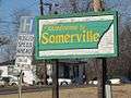
Somerville, Tennessee
| Somerville, Tennessee | |
|---|---|
| Town | |
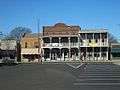
 Somerville Courthouse | |
 Location of Somerville in Fayette County, Tennessee. | |
| Coordinates: 35°14′15″N 89°21′30″W / 35.23750°N 89.35833°WCoordinates: 35°14′15″N 89°21′30″W / 35.23750°N 89.35833°W | |
| Country | United States |
| State | Tennessee |
| County | Fayette |
| Area | |
| • Total | 12.5 sq mi (32.5 km2) |
| • Land | 12.4 sq mi (32.1 km2) |
| • Water | 0.2 sq mi (0.4 km2) |
| Elevation | 397 ft (121 m) |
| Population (2010) | |
| • Total | 3,094 |
| • Estimate (2016)[1] | 3,137 |
| • Density | 250/sq mi (96.4/km2) |
| Time zone | UTC-6 (Central (CST)) |
| • Summer (DST) | UTC-5 (CDT) |
| ZIP code | 38068 |
| Area code(s) | 901 |
| FIPS code | 47-69620[2] |
| GNIS feature ID | 1303713[3] |
| Website |
www |
Somerville is a town in Fayette County, Tennessee, United States. It is part of the Memphis metropolitan area. The population was 3,094 at the 2010 census,[4] up from 2,519 at the 2000 census. It is the county seat of Fayette County.[5]
History
The town was named to honor Lieutenant Robert Somerville, who was killed in 1814 during the Battle of Horseshoe Bend in central Alabama while serving under General Andrew Jackson.[6] Somerville was incorporated in 1836.
Geography
Somerville is located slightly northeast of the center of Fayette County at 35°14′15″N 89°21′30″W / 35.23750°N 89.35833°W (35.237623, -89.358400).[7] U.S. Route 64 runs through the center of town as Fayette Street, leading northeast 13 miles (21 km) to Whiteville and west 9 miles (14 km) to Oakland. Downtown Memphis is 41 miles (66 km) to the west. Tennessee State Route 76 crosses US 64 at the center of town. North of US 64, it is the town's Main Street and leads 26 miles (42 km) to Brownsville. To the south it is South Street, leading 13 miles (21 km) to Moscow.
According to the United States Census Bureau, the town has a total area of 11.4 square miles (30 km2), of which 11.2 square miles (29 km2) is land and 0.2 square miles (0.52 km2) (1.58%) is water. The Loosahatchie River, a west-flowing tributary of the Mississippi, runs past the northern end of the town.
Demographics
| Historical population | |||
|---|---|---|---|
| Census | Pop. | %± | |
| 1860 | 1,526 | — | |
| 1870 | 954 | −37.5% | |
| 1880 | 834 | −12.6% | |
| 1890 | 892 | 7.0% | |
| 1900 | 777 | −12.9% | |
| 1910 | 1,387 | 78.5% | |
| 1920 | 1,106 | −20.3% | |
| 1930 | 1,333 | 20.5% | |
| 1940 | 1,570 | 17.8% | |
| 1950 | 1,760 | 12.1% | |
| 1960 | 1,820 | 3.4% | |
| 1970 | 1,816 | −0.2% | |
| 1980 | 2,264 | 24.7% | |
| 1990 | 2,047 | −9.6% | |
| 2000 | 2,519 | 23.1% | |
| 2010 | 3,094 | 22.8% | |
| Est. 2016 | 3,137 | [1] | 1.4% |
| Sources:[8][9] | |||
As of the census[2] of 2000, there were 2,519 people, 1,006 households, and 618 families residing in the town. The population density was 225.4 people per square mile (87.1/km²). There were 1,070 housing units at an average density of 95.8 per square mile (37.0/km²). The racial makeup of the town was 59.94% White, 39.38% African American, 0.08% Native American, 0.08% Asian, 0.04% from other races, and 0.48% from two or more races. Hispanic or Latino of any race were 0.24% of the population.
There were 1,006 households out of which 27.9% had children under the age of 18 living with them, 39.3% were married couples living together, 19.8% had a female householder with no husband present, and 38.5% were non-families. 36.9% of all households were made up of individuals and 19.6% had someone living alone who was 65 years of age or older. The average household size was 2.33 and the average family size was 3.08.
In the town, the population was spread out with 24.3% under the age of 18, 10.0% from 18 to 24, 24.9% from 25 to 44, 20.0% from 45 to 64, and 20.8% who were 65 years of age or older. The median age was 39 years. For every 100 females, there were 84.7 males. For every 100 females age 18 and over, there were 76.6 males.
The median income for a household in the town was $21,225, and the median income for a family was $29,750. Males had a median income of $26,094 versus $22,768 for females. The per capita income for the town was $15,636. About 18.3% of families and 25.4% of the population were below the poverty line, including 29.0% of those under age 18 and 25.0% of those age 65 or over.
Notable people
- Chester R. Allen (1905-1972), Major general in the Marine Corps and former Quartermaster General
- Elizabeth Bolden (1890-2006), supercentenarian, world's oldest living person in 2006, died in Memphis
- W. Herbert Brewster (1897–1987), influential African American Baptist minister, composer, dramatist, singer, poet and community leader; he is considered to be one of the fathers of gospel music
- Herb Parsons (1908-1959), considered by many to be the greatest exhibition shooter in history
- Ingram Stainback (1883-1961), territorial governor of Hawaii; born in Somerville
- William L. Wainwright (1947-2012), North Carolina politician
References
- 1 2 "Population and Housing Unit Estimates". Retrieved June 9, 2017.
- 1 2 "American FactFinder". United States Census Bureau. Retrieved 2008-01-31.
- ↑ "US Board on Geographic Names". United States Geological Survey. 2007-10-25. Retrieved 2008-01-31.
- ↑ "Geographic Identifiers: 2010 Demographic Profile Data (G001): Somerville town, Tennessee". U.S. Census Bureau, American Factfinder. Retrieved August 16, 2016.
- ↑ "Find a County". National Association of Counties. Retrieved 2011-06-07.
- ↑ Fayette County Chamber of Commerce: Somerville.
- ↑ "US Gazetteer files: 2010, 2000, and 1990". United States Census Bureau. 2011-02-12. Retrieved 2011-04-23.
- ↑ "Census of Population and Housing: Decennial Censuses". United States Census Bureau. Retrieved 2012-03-04.
- ↑ "Incorporated Places and Minor Civil Divisions Datasets: Subcounty Resident Population Estimates: April 1, 2010 to July 1, 2012". Population Estimates. U.S. Census Bureau. Archived from the original on 17 June 2013. Retrieved 11 December 2013.
External links
Gallery

| Wikimedia Commons has media related to Somerville, Tennessee. |


Municipalities and communities of Fayette County, Tennessee, United States | ||
|---|---|---|
| Cities | ||
| Towns | ||
| Unincorporated communities | ||
| Footnotes | ‡This populated place also has portions in an adjacent county or counties | |