Solar eclipse of May 3, 1715
| Solar eclipse of May 3, 1715 | |
|---|---|
 Map | |
| Type of eclipse | |
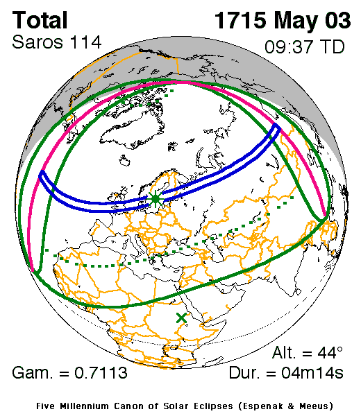
| Nature | Total |
| Gamma | 0.7112 |
| Magnitude | 1.0632 |
| Maximum eclipse | |
| Duration | 254 sec (4 m 14 s) |
| Coordinates | 59°24′N 17°54′E / 59.4°N 17.9°E |
| Max. width of band | 295 km (183 mi) |
| Times (UTC) | |
| Greatest eclipse | 9:36:30 |
| References | |
| Saros | 114 (60 of 72) |
| Catalog # (SE5000) | 8826 |
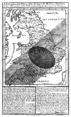
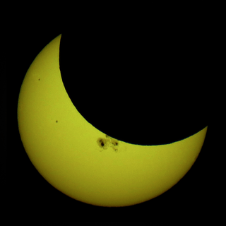
A total solar eclipse occurred on 3 May 1715. A solar eclipse occurs when the Moon passes between Earth and the Sun, thereby totally or partly obscuring the image of the Sun for a viewer on Earth. Totality occurs in a narrow path across Earth's surface, with the partial solar eclipse visible over a surrounding region thousands of kilometres wide. The 1715 total eclipse was visible across England and Wales, northern Europe, and northern Asia.

The wide (faint) shadow shows for the penumbra (partiality), and the smaller dark shadow shows for the umbra (totality).
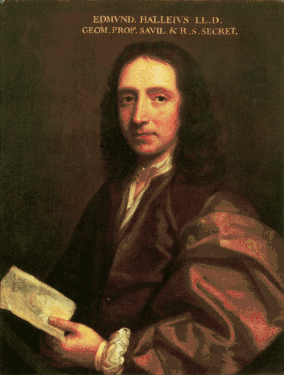
The 1715 eclipse is known as Halley's Eclipse, after Edmond Halley (1656–1742) who predicted this eclipse to within 4 minutes accuracy. Halley observed the eclipse from London where the city of London enjoyed 3 minutes 33 seconds of totality. He also drew a predictive map showing the path of totality across England. The original map was about 20 miles off the observed eclipse path, mainly due to his use of inaccurate lunar ephemeris. After the eclipse, he corrected the eclipse path, and added the path and description of the 1724 total solar eclipse.[1]
Drawing upon lunar tables made by the first Astronomer Royal John Flamsteed, William Whiston produced a more technical predictive eclipse map around the same time as Halley. Both Halley's and Whiston's maps were published by John Senex in March 1715.[2][3]
Totality was observed in England from Cornwall in the south-west to Lincolnshire and Norfolk in the east. It was also observed in Ireland, where large crowds turned out in Dublin to watch it: the weather in Dublin was exceptionally cold and wet, and the eminent judge Joseph Deane caught a fatal chill as a result.
Note: Great Britain didn't adopt the Gregorian calendar until 1752, so the date was at the time considered 22 April 1715.
|

Related eclipses
It is a part of solar Saros 114.
See also
References
- ↑ Westfall, John; Sheehan, William (2014). Celestial Shadows: Eclipses, Transits, and Occultations. Springer. p. 115. ISBN 978-1-4939-1535-4.
- ↑ Pasachoff, J. M. (1999) "Halley and his maps of the Total Eclipses of 1715 and 1724" Journal of Astronomical History and Heritage' (ISSN 1440-2807), Vol. 2, No. 1, p. 39-54
- ↑ Rebekah Higgitt (3 May 2015). "Halley's Eclipse: a coup for Newtonian prediction and the selling of science". The Guardian.
External links
| Wikimedia Commons has media related to Solar eclipse of 1715 May 3. |
- Total Eclipses of the Sun, By Mabel Loomis Todd, 1894, new and revised edition by David P. Todd, 1900.
- Halley's eclipse Hans van der Meer's Eclipse Page
- Halley is credited with the first eclipse map showing the path of the Moon's shadow across England during the upcoming total eclipse of 1715.
- Halley's Maps and Descriptions of the 1715 Total Solar Eclipse
- Edmund Halley, Observations of the Late Total Eclipse of the Sun on the 22d of April Last Past, Made before the Royal Society at Their House in Crane-Court in Fleet-Street, London. by Dr. Edmund Halley, Reg. Soc. Secr. with an Account of What Has Been Communicated from Abroad concerning the Same, Phil Trans R Soc 1714 29: 245-262.
- Whiston's predictive map of March 1715
Further reading
- Walters, A.N. (1999) "English Broadsides of Early Eighteenth-century Solar Eclipses"

