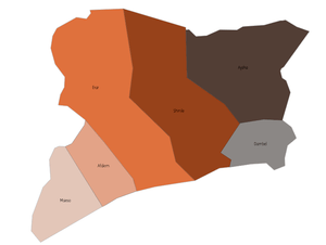
Sitti Zone
| Sitti Zone Gobolka Sitti | |
|---|---|
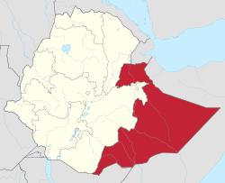
 Map of Sitti Zone | |
 | |
| Country | Ethiopia |
| Region | Somali |
| Zone | Sitti |
| Capital | Shinile |
| Area | |
| • Total | 29,693 km2 (11,465 sq mi) |
| Population (2014) | |
| • Total | 946,968 |
| Time zone | UTC+3 (EAT) |
Sitti Zone (Somali: Gobolka Sitti), formerly known as Shinile, is one of nine Zones of the Somali Region of Ethiopia.
Located at the northwestern point of the Somali Region and stretching across the savanna north of the Ahmar Mountains, Sitti is bordered on the south by Dire Dawa and the Oromia Region, on the west by the Afar Region, on the north by Djibouti, on the east by Somalia, and on the southeast by Jijiga. Other towns and cities in this zone include Aysha, Adi Gala, Shinile, Dewele, Harewa, Adigale, Erer, Bike and Āfdem. Part of the northwestern corner is occupied by the Yangudi Rassa National Park, which is a notable local landmark.
Geography
The majority of Issa now live as agropastoralists. They cultivate sorghum and maize in the south of the zone, in the hilly area at the foot of the highlands, and mainly keep cattle. A total of 15-25% of the inhabitants of the Sitti zone are agropastoralists. This way of life has already entered the Dembel since about 1965. In other areas, cattle breeders started to cultivate agriculture, especially in the early 1990s. They were able to reduce their cattle herds and adapt themselves to the recurring droughts. The transition to Agropastoralism was also promoted by the Ethiopian government. In addition, the Somali wanted to catch up with Oromo peasants from the highlands, who increasingly went to the lowland to cultivate the Somalis land claimed there.
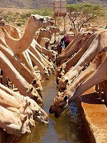
The most important livelihoods are livestock farming and some arable farming (agropastoralism). 75-85% of the population - especially the Issa are cattle breeders, mainly sheep and cattle, in less productive areas camels and goats. Even households which do not have camel herds, at least keep a camel as a beast of burden. In the dry season, sheep and dairy-producing animals remain near the villages, while camels, cattle and goats are kept in other pastoral areas. The cattle breeders mainly feed on the milk and ghee produced therefrom, they also sell cattle and mainly buy sorghum and sugar.
Climate
The Sitti Zone has cold winters than the highlands, while the lowlands has mild winters. The region elevation is the major factor in temperature levels, with the higher areas, on average, as 17°C (62°F) cooler, day or night. Hot summer days are tempered by the low relative humidity and cooler evenings during summer months since, for most of the state, the highest diurnal difference in temperature is often in the summer.
The annual mean statistics for some Sitti Zone centres is shown below:
| Town | Min. Temp | Max. Temp | Rainfall |
|---|---|---|---|
| Shinile | 15.1 °C (59.2 °F) | 35.0 °C (95.0 °F) | 557 mm (21.9 in) |
| Dewele | 15.9 °C (60.6 °F) | 36.9 °C (98.4 °F) | 208 mm (8.2 in) |
| Bike | 14.5 °C (58.1 °F) | 34.1 °C (93.4 °F) | 660 mm (26 in) |
| Āfdem | 14.5 °C (58.1 °F) | 34.7 °C (94.5 °F) | 649 mm (25.6 in) |
| Aysha | 16.6 °C (61.9 °F) | 37.3 °C (99.1 °F) | 223 mm (8.8 in) |
Demographics
Based on the 2017 Census conducted by the Central Statistical Agency of Ethiopia (CSA), this Zone has a total population of 591,901, of whom 308,215 are men and 283,686 women. While 86,493 are urban inhabitants, a further 505,410 were pastoralists.
Based on the 2007 Census conducted by the Central Statistical Agency of Ethiopia (CSA), this Zone has a total population of 457,086 of whom 246,302 are men and 210,784 women. While 64,263 or 14.06% are urban inhabitants, a further 203,285 or 44.47% were pastoralists. Two largest ethnic groups reported in Sitti were the Somalis (97.03%) and Amhara (1.42%); all other ethnic groups made up 1.55% of the population. Somali language is spoken as a first language by 96.91%, Amharic by 1.36%, and Oromo by 1.34%; the remaining 0.39% spoke all other primary languages reported. 98.35% of the population said they were Muslim.[1]
The 1994 national census reported a total population for this Zone of 258,703 in 34,617 households, of whom 121,094 were men and 137,609 were women; 53,374 or 14.88% of its population were urban dwellers. The largest ethnic group reported in Shinile was the Somali (95%); a similar share spoke Somali (95%). Only 12,085 or 3.4% were literate.[2]
According to a May 24, 2004 World Bank memorandum, none of the inhabitants of Sitti have access to electricity, this zone has a road density of 17.3 kilometers per 1000 square kilometers, the average rural household has 1.2 hectare of land (compared to the national average of 1.01 hectare of land and an average of 2.25 for pastoral Regions)[3] and the equivalent of 1.4 heads of livestock. The memorandum gave this zone a drought risk rating of 387.[4]
Agriculture
On 5–23 November 2003, the CSA conducted the first ever national agricultural census, of which the livestock census was an important component.[5] For the Somali Region, the CSA generated estimated figures for the livestock population (cattle, sheep, goats, camels, and equids) and their distribution by commissioning an aerial survey. For the Sitti Zone, their results included:
| Animal | Estimated total | number per sqk. |
|---|---|---|
| cattle | 207,472 | 6.8 |
| sheep | 670,956 | 49.5 (including goats) |
| goats | 849,451 | 49.5 (including sheep) |
| camels | 103,052 | 3.4 |
| asses | 16,138 | 0.5 (all equids) |
| mules | 191 | 0.5 (all equids) |
| horses | 0 | |
Towns
| Town names | Population |
|---|---|
| Shinile | 100,132 |
| Dewele | 3,357 |
| Lasarat | 2,269 |
| Aysha | 1,321 |
| Hadigale | 10,702 |
| Milo | 2,173 |
| Harewa | 1,787 |
| Hurso | 3,318 |
| Erer | 7,490 |
| Gotha | 869 |
| Biki | 9,197 |
| Āfdem | 4,746 |
| Aydora | 2,168 |
| Asbuli | 98,490 |
Notes
- ↑ Census 2007 Tables: Somali Region, Tables 2.1, 2.4, 3.1, 3.2 and 3.4.
- ↑ 1994 Population and Housing Census of Ethiopia: Results for Somali Region, Vol. 1 Archived November 19, 2008, at the Wayback Machine. Tables 2.1, 2.8, 2.12, 2.15, 3.7 (accessed 1 January 2009).
- ↑ Comparative national and regional figures comes from the World Bank publication, Klaus Deininger et al. "Tenure Security and Land Related Investment", WP-2991 Archived 2007-03-10 at the Wayback Machine. (accessed 23 March 2006). This publication defines Benishangul-Gumaz, Afar and Somali as "pastoral Regions".
- ↑ World Bank, Four Ethiopias: A Regional Characterization (accessed 23 March 2006).
- ↑ "Livestock aerial survey in the Somali Region" Archived 2011-07-16 at the Wayback Machine., CSA (November 2003), Tables 4, 6 (accessed 17 May 2009)
Coordinates: 10°15′N 42°00′E / 10.250°N 42.000°E
Zones of the Somali Region | ||
|---|---|---|