Taga Castle
| Taga Castle 多賀城 | |
|---|---|
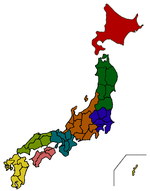
| Tagajō, Miyagi Prefecture, Japan | |
 | |
 Taga Castle 多賀城  Taga Castle 多賀城 | |
| Coordinates | 38°18′24″N 140°59′18″E / 38.30667°N 140.98833°ECoordinates: 38°18′24″N 140°59′18″E / 38.30667°N 140.98833°E |
| Type | jōsaku-style Japanese castle |
| Site information | |
| Open to the public | yes |
| Condition | archaeological site |
| Site history | |
| Built | 7th century AD |
| Demolished | unknown |
Taga Castle (多賀城 Tagajō ato) is the site of a Nara period jōsaku-style Japanese castle in what is now part of the town of Tagajō in Miyagi prefecture in the Tōhoku region of far northern Honshu, Japan. Bashō tells of his visit to the site in Oku no Hosomichi. The ruins of Taga-jō and its former temple have been designated a Special Historic Site (特別史跡).[1][2]
History
In the late Nara period, after the establishment of a centralized government under the Ritsuryō system, the Yamato court sent a number of military expeditions to what is now the Tōhoku region of northern Japan to bring the local Emishi tribes under its control.[3]
An inscription gives a foundation date of 724 AD for Tagajō and states that it was constructed by Azumabito Ono as the provisional provincial capital of Mutsu Province. Along with Akita Castle and Okachi Fort in Dewa Province, it was one of the main bases for Yamato expansion into northern Honshu. Its commander was titled Chinjufu Shogun (鎮守府) and was the northern equivalent to the commander of Dazaifu (太宰府) in Kyushu.[4] The castle was significantly renovated by Fujiwara Asakari in 762.
Tagajō was rebuilt after being sacked and burned by the Emishi in 780, before being badly damaged by the Jōgan tsunami of 869.[5][6]
From 802 AD, the frontier between Yamato and Emishi territories shifted further north due to the successful campaigns of Sakanoue no Tamuramaro, and with the construction of Isawa Castle, Taga Castle gradually lost importance. It was retained as a center for administrative functions, but most military activities were transferred to various northern strongholds.
The rise of Hiraizumi in the twelfth century saw its final demise.[7]
The site was discovered and partially excavated in 1955, with more extensive investigations in 1976.[8]
Description
The ruins are located on a plateau near the coast of what is now Miyagi Prefecture.
The fortification was a square enclosure, approximately 3.4 kilometers in circumference, consisting of a 5-meter high earthen rampart surmounted by a wooden palisade, and protected by a 3-4 meter wide dry moat. In the center was a square compound, also with earthen walls, containing government administrative buildings, workshops and storehouses.[3]
About a kilometer south of the Taga Castle ruins are the ruins of a large Buddhist temple complex, and outside the southern wall of the castle are the ruins of a planned settlement.
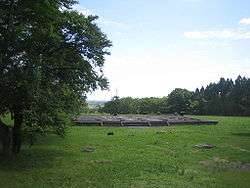
The site today has preserved the foundation stones of Taga Castle in a park-like setting.
Monument
The Tsubo no Ishibumi (壺の碑) or Tagajōhi (多賀城碑) is a Nara period inscription that gives distances to the capital at Nara, the province of the Emishi, and other regions.[9]
Matsuo Bashō (松尾 芭蕉) creatively recounts his viewing of the stele in Oku no Hosomichi (奥の細道), concluding 'there are seldom any certain vestiges of what has been, yet in this place there are wholly trustworthy memorials of events a millennium ago' and is moved to tears. In his account the monument functions as a poetic place or utamakura.[10]
In 1998 it was designated an Important Cultural Property.[11]
Tagajō Temple ruins

Excavations to the southeast of the fort have uncovered the ruins of a temple, now known as Tagajō Haiji. Five buildings have been identified inside a large rectangular compound enclosed by an earthen wall.[12]
Museum
The Tōhoku History Museum (東北歴史博物館), on the grounds of the Taga Castle, has finds from the excavations as well as from other sites in Tōhoku.[13]
See also
References
- ↑ "Database of Registered National Cultural Properties". Agency for Cultural Affairs. Archived from the original on 26 March 2012. Retrieved 16 March 2011.
- ↑ "Tagajō". Miyagi Prefecture. Archived from the original on 26 March 2012. Retrieved 16 March 2011.
- 1 2 Shively, Donald H.; McCullough, William H. (1999). Cambridge History of Japan vol. II (p.31f.). Cambridge University Press.
- ↑ Yiengpruksawan, Mimi Hall (1998). Hiraizumi: Buddhist Art and Regional Politics in Twelfth-Century Japan. Harvard University Press. pp. 19–22.
- ↑ Yiengpruksawan, Mimi Hall (1998). Hiraizumi: Buddhist Art and Regional Politics in Twelfth-Century Japan. Harvard University Press. p. 26.
- ↑ Minoura, K. (et al.) (2001). "The 869 Jōgan tsunami deposit and recurrence interval of large-scale tsunami on the Pacific coast of northeast Japan" (PDF). Journal of Natural Disaster Science. 23 (2): 83–88. Archived from the original (PDF) on 2011-04-01.
- ↑ Yiengpruksawan, Mimi Hall (1998). Hiraizumi: Buddhist Art and Regional Politics in Twelfth-Century Japan. Harvard University Press.
- ↑ "城生柵跡 じょうのさくあと". Cultural Heritage Online (in Japanese). Agency for Cultural Affairs. Retrieved 25 December 2016.
- ↑ "Tagajō - Inscription (in Japanese)". Miyagi Prefecture. Archived from the original on 12 May 2011. Retrieved 16 March 2011.
- ↑ Miner, Earl (1996). Naming Properties: Nominal Reference in Travel Writings by Basho and Sora, Johnson and Boswell. University of Michigan Press. pp. 127–135.
- ↑ "Database of Registered National Cultural Properties". Agency for Cultural Affairs. Archived from the original on 26 March 2012. Retrieved 16 March 2011.
- ↑ Yiengpruksawan, Mimi Hall (1998). Hiraizumi: Buddhist Art and Regional Politics in Twelfth-Century Japan. Harvard University Press. pp. 23f.
- ↑ "Special Historic Site - Tagajo Ruins (in Japanese)". Miyagi Prefecture. Archived from the original on 11 September 2012. Retrieved 16 March 2011.
External links
| Wikimedia Commons has media related to Taga Castle. |
(in Japanese) Tagajō Tourist Association
- Excavation report The Comprehensive Database of Archaeological Site Reports in Japan.
- Miyagi Prefectural Agency for Cultural Affairs
- JCastle info