Shirley Township, Cloud County, Kansas
| Shirley Township | |
|---|---|
| Township | |
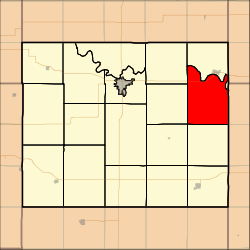 Location in Cloud County | |
| Coordinates: 39°31′30″N 098°25′21″W / 39.52500°N 98.42250°WCoordinates: 39°31′30″N 098°25′21″W / 39.52500°N 98.42250°W | |
| Country | United States |
| State | Kansas |
| County | Cloud |
| Area | |
| • Total | 42.75 sq mi (110.72 km2) |
| • Land | 42.5 sq mi (110.06 km2) |
| • Water | 0.26 sq mi (0.66 km2) 0.6% |
| Elevation | 1,542 ft (470 m) |
| Population (2000) | |
| • Total | 178 |
| • Density | 4.2/sq mi (1.6/km2) |
| GNIS feature ID | 0473353 |
Shirley Township is a township in Cloud County, Kansas, USA. As of the 2000 census, its population was 178.
Demographics
Shirley is an historically French American community, most of whom are of French Canadian ancestry.[1]
History
Shirley Township was organized in 1866.[2]
Geography
Shirley Township covers an area of 42.75 square miles (110.7 km2) and contains no incorporated settlements. According to the USGS, it contains two cemeteries: Cedar Hill and Pleasant View.
The stream of Beaver Creek runs through this township.
References
- ↑ Robley, T. F. (1894). History of Bourbon County, Kansas: To the Close of 1865. Press of the Monitor book & printing Company. p. 71.
- ↑ Hollibaugh, E. F. (1903). Biographical History of Cloud County, Kansas: Biographies of Representative Citizens. Illustrated with Portraits of Prominent People, Cuts of Homes, Stock, Etc. Wilson, Humphrey & Company. p. 69.
External links
Municipalities and communities of Cloud County, Kansas, United States | ||
|---|---|---|
| Cities | 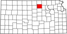 | |
| Unincorporated communities | ||
| Townships | ||
| Footnotes | ‡This populated place also has portions in an adjacent county or counties | |
This article is issued from
Wikipedia.
The text is licensed under Creative Commons - Attribution - Sharealike.
Additional terms may apply for the media files.