Lawrence Township, Cloud County, Kansas
| Lawrence Township | |
|---|---|
| Township | |
 Location in Cloud County | |
| Coordinates: 39°38′15″N 097°32′31″W / 39.63750°N 97.54194°WCoordinates: 39°38′15″N 097°32′31″W / 39.63750°N 97.54194°W | |
| Country | United States |
| State | Kansas |
| County | Cloud |
| Area | |
| • Total | 36.46 sq mi (94.44 km2) |
| • Land | 36.02 sq mi (93.29 km2) |
| • Water | 0.45 sq mi (1.15 km2) 1.22% |
| Elevation | 1,371 ft (418 m) |
| Population (2000) | |
| • Total | 146 |
| • Density | 4.1/sq mi (1.6/km2) |
| GNIS feature ID | 0473089 |
Lawrence Township is a township in Cloud County, Kansas, USA. As of the 2000 census, its population was 146.
History
Lawrence Township was organized in 1872. It was named for L. D. Lawrence, a pioneer settler.[1]
Geography
Lawrence Township covers an area of 36.46 square miles (94.4 km2) and contains no incorporated settlements. According to the USGS, it contains two cemeteries: Hollis and Walnut Grove.
The streams of Little Upton Creek, Oak Creek, Plum Creek, Salt Creek, Upton Creek and West Creek run through this township.
References
- ↑ Hollibaugh, E. F. (1903). Biographical History of Cloud County, Kansas: Biographies of Representative Citizens. Illustrated with Portraits of Prominent People, Cuts of Homes, Stock, Etc. Wilson, Humphrey & Company. p. 73.
External links
Municipalities and communities of Cloud County, Kansas, United States | ||
|---|---|---|
| Cities | 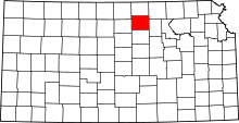 | |
| Unincorporated communities | ||
| Townships | ||
| Footnotes | ‡This populated place also has portions in an adjacent county or counties | |
This article is issued from
Wikipedia.
The text is licensed under Creative Commons - Attribution - Sharealike.
Additional terms may apply for the media files.