Shaharah
| Shaharah | |
|---|---|
| Village | |
 Shaharah | |
 Shaharah | |
| Coordinates: 16°11′1″N 43°42′12″E / 16.18361°N 43.70333°ECoordinates: 16°11′1″N 43°42′12″E / 16.18361°N 43.70333°E | |
| Country |
|
| Governorate | 'Amran |
| District | Shaharah |
| Elevation | 2,600 m (8,500 ft) |
| Time zone | UTC+3 (Yemen Standard Time) |
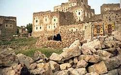
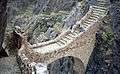
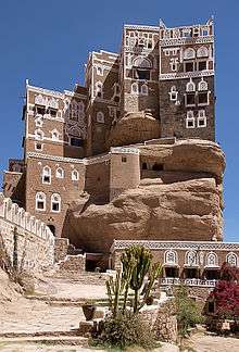
Shahareh or Shehara (Arabic: شهارة) is a large mountain village and seat of Shaharah District of the 'Amran Governorate, Yemen. The village "lies at 2600 metres and overlooks mountainous bulging swells to the south and shimmering hot plains to the north."[1] The village, which lies on top a sharp mountain of the same name, Jabal Shaharah,[2] consists of several old stone houses and a cistern. The area is noted for its limestone arch footbridge, constructed in the 17th century by a local lord to connect two villages across a deep gorge.[3][1]


References
- 1 2 Walker, Jenny; Butler, Stuart (1 October 2010). Oman, UAE & Arabian Peninsula. Lonely Planet. p. 464. ISBN 978-1-74179-145-7. Retrieved 13 April 2012.
- ↑ Mackintosh-Smith, Tim (8 December 2011). Yemen. John Murray. p. 92. ISBN 978-1-84854-696-7. Retrieved 13 April 2012.
- ↑ "Bridge". Lonely Planet. Retrieved 13 April 2012.
External links
| Wikimedia Commons has media related to Shaharah. |
| 1,000,000 and more | |
|---|---|
| 100,000-999,999 | |
| 10,000-99,999 | |
| <9,999 | |
1Main Island become under control by United Arab Emirates since April 30, 2018 | |
| World Heritage Sites |
| |||||||||||||
|---|---|---|---|---|---|---|---|---|---|---|---|---|---|---|
| ||||||||||||||
This article is issued from
Wikipedia.
The text is licensed under Creative Commons - Attribution - Sharealike.
Additional terms may apply for the media files.