Ibb
| Ibb إب | |
|---|---|
 | |
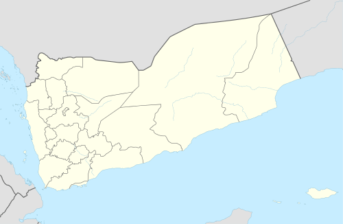 Ibb Location in Yemen | |
| Coordinates: 13°58′N 44°10′E / 13.967°N 44.167°ECoordinates: 13°58′N 44°10′E / 13.967°N 44.167°E | |
| Country |
|
| Governorate | Ibb Governorate |
| Population (2005) | |
| • Total | 800,000 |
| Time zone | UTC+3 (Yemen Standard Time) |
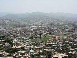
Ibb (or Abb) (Arabic: إب ʾIbb) is a city in Yemen, the capital of Ibb Governorate, located about 117 km (73 mi) northeast of Mocha and 194 km (121 mi) south of Sana'a.[1] A market town and administrative centre developed during the Ottoman occupation, it is one of the most important medium-sized cities in the country.[2] It is situated on a mountain ridge, surrounded by fertile land. As of 2005, it had a population of 160,000.
History
.jpg)
Ibb has been occupied since early Islamic times, and due to its strategical importance, the Ottomans used it as an administrative centre.[1] It thrived as a market town and the Ottomans established the Wednesday market in Ibb.[3] Ibb was governed by a semi-autonomous emir until 1944, when the emirate was abolished. At times in its history many people have migrated to Ibb from areas of Yemen which had been experiencing drought, to find work in farming.[4] In the mid 1950s there was reportedly an outbreak of smallpox in the city.[5]
German explorer, Hermann Burchardt, photographed the city in 1901, photos now held at the Ethnological Museum of Berlin.[6]
Climate
Ibb is located at an altitude of 2,050 metres (6,730 ft) on a spur of Mount Shamāḥī.[7] Due to its high altitude, Ibb has a subtropical highland climate (Köppen climate classification: Cwa), and is one of the wettest areas of Yemen,[1] typically receiving 800–1200 mm of rain per annum.
| Climate data for Ibb (1950 m) | |||||||||||||
|---|---|---|---|---|---|---|---|---|---|---|---|---|---|
| Month | Jan | Feb | Mar | Apr | May | Jun | Jul | Aug | Sep | Oct | Nov | Dec | Year |
| Average high °C (°F) | 21.0 (69.8) |
21.1 (70) |
23.6 (74.5) |
25.5 (77.9) |
27.8 (82) |
30.1 (86.2) |
29.7 (85.5) |
27.9 (82.2) |
25.7 (78.3) |
23.1 (73.6) |
21.0 (69.8) |
20.8 (69.4) |
24.8 (76.6) |
| Average low °C (°F) | 7.9 (46.2) |
9.3 (48.7) |
10.4 (50.7) |
12.7 (54.9) |
15.5 (59.9) |
16.9 (62.4) |
18.8 (65.8) |
18.4 (65.1) |
15.5 (59.9) |
11.1 (52) |
8.7 (47.7) |
8.1 (46.6) |
12.8 (55) |
| Average precipitation mm (inches) | 5.8 (0.228) |
4.6 (0.181) |
12.9 (0.508) |
16.0 (0.63) |
10.2 (0.402) |
48.8 (1.921) |
150.0 (5.906) |
144.6 (5.693) |
74.2 (2.921) |
32.5 (1.28) |
14.1 (0.555) |
5.3 (0.209) |
519 (20.434) |
| Source: National Weather Service | |||||||||||||
Notable landmarks
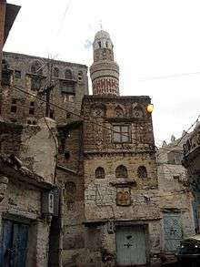
The city is noted for its towering stone houses, with geometrical friezes and circular stained glass windows known as qamiriya.[1] The main mosque was built during the Ottoman period, and there are other mosques and also a fortress in the vicinity, closed to visitors. An ancient overhead aqueduct still remains.[8] Ibb University was established in 1996. Ibb also contains an art centre and museum and hotels such as Saba Tourist Hotel and Al-Riyad Hotel.[1] The main football team is Al Sha'ab Ibb.
Notable people
- Abdul Aziz Al-Maqaleh - poet and writer
- Zayd Mutee' Dammaj - Yemen foremost novelist
- Abdul Rahman al-Iryani - former President of Yemen
- Brian "The Lion" Mihtar - professional boxer
- Abdul Majeed al-Zindani - founder and head of the Iman University.
- Hamdan Dammag - A novelist and computer Scientist.
See also
References
| Wikimedia Commons has media related to Ibb. |
- 1 2 3 4 5 Carter, Terry; Dunston, Lara (2007). Oman, UAE & Arabian Peninsula. Lonely Planet. p. 484. ISBN 978-1-74104-546-8.
- ↑ Wald, Peter (1996). Yemen. Pallas Athene. p. 179. ISBN 978-1-873429-11-2.
- ↑ Blumi, Isa (30 July 2010). Chaos in Yemen: Societal Collapse and the New Authoritarianism. Taylor & Francis. p. 87. ISBN 978-0-203-84742-8.
- ↑ Burrowes, Robert D. (2010). Historical Dictionary of Yemen. Rowman & Littlefield. p. 169. ISBN 978-0-8108-5528-1.
- ↑ El-Khalidi, Hatem (September 2011). Sojourn in a Dreadful Land (Yemen Chronicles). Dorrance Publishing. p. 13. ISBN 978-1-4349-1197-1.
- ↑ Ibb, by Hermann Burchardt (Click on photo to enlarge); Whitewashed houses.
- ↑ "Ibb". Encyclopædia Britannica. Retrieved 22 November 2013.
- ↑ Ingrams, William Harold (1964). The Yemen: Imams, rulers & revolutions. Praeger. p. 31.
| 1,000,000 and more | |
|---|---|
| 100,000-999,999 | |
| 10,000-99,999 | |
| <9,999 | |
1Main Island become under control by United Arab Emirates since April 30, 2018 | |