Chak 129 N.B. (چک نمبر ۱۲۹ شمالی)
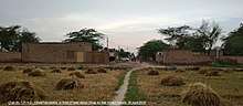
Chak No.129 N.B. (چک نمبر۱۲۹ شمالی)[2] commonly known as Unatti Moar (اُنتی موڑ) is a village of Tehsil Sillan-wali [3] (سِلاں والی) located at Sillanwali-Farooka Road on the western bank of Lower Jehulm Canal in Sargodha District,[4] Punjab, Pakistan.[5] It is headquarters of the Union Council No. 120, comprising Chak No's. 125, 126, 127, 128 and 129 N۔B.
Access
It is easily accessible from major cities i.e. Sargodha, Chiniot, Faislabad, Jhang and Sahiwal via Sargodha Road, Farooka (فروکہ) Road, Barana (بڑانہ) Road,Shah Nikder (شاہ نکدر) Road and a railway track. The railway track was laid down by British Government in 1904.
History & Settlement
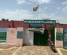
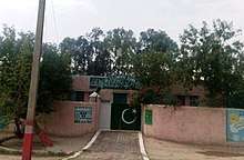
According to elders, before colonial settlement, there was a pond in its western side where a Hindu Yogi (Saadhu) lived due to which the village was also called Saadh wala (سادھ والا). The people from far flung area came with their cattle to the pond for drinking water. The Chak was established by the British Government of India after completion of northern branch of Lower Jehlum Canal in 1901 under 1st Colonization Officer of Sargodha Mr. Malcolm Hailey.[7] So it was one of many villages settled in British Colony of Lower Jehlum Canal Sargodha.[8] Initially it was part of Tehsil and District Shahpur.[9] Major population consists of the settlers from Rawalpindi, Jehlum, and Chakwal who were rewarded agriculture land in turn of their services rendered for the British Army. As they got monthly pension for their service so were also called "Pensioners" (پنسلی) in local language. The second major portion came from Indian Punjab after partition in 1947 therefore called Muhajirs. Most of them were Raajput (راجپوت) by caste and were allotted houses of the Hindus who resided here before partition, The last settlement was made for affected families of Mangla Dam[10] (AJK) around 1970 and therefore called Mangla Demis. Most of Baloch families migrated from the inundated area of River Jehlum who timely were displaced due to flood but afterwards became permanent residents. Remaining population is mix up of different castes. Comparatively a well developed village, it has its own Govt. Girls High School,[11] Union Council office and a Livestock dispensary, five mosques, one private hospital and two private schools.
Demography
About 35 km away from Sargodha city southward and 3 km from its Tehsil headquarters Sillanwali, the village occupies a central place by joining Faruka Road, Lalian Road, Sillanwali Road, Jhang Road and Sargodha Road. It is surrounded by Chak 125 NB in north west and Chak 127 NB in north, Sillanwali city in north east, Chak 130 NB in east, Chak 144/145 NB in south west and Chak 128 NB in west. According to Census 2017, its population is 3612. Major clans are Rajput, Syed, Mirza, Mangla Daimi, Awan, Khokhar, Arain, Janjua, Raja and Baloch etc.
Agriculture
Majority of people living in this village are farmers who own their land, but as times change, these people have been progressively going into business. The village is still entirely agricultural. Its major crops are wheat, sugar cane, cotton, barley, oats, pulses and citrus etc. The northern branch of Lower Jhelum Canal (constructed in 1900), provides better irrigation to the village. The village contains fertile land and is surrounded by lush green beautiful citrus orchards and agricultural farms.
Fauna & Flora
The area consists of all major wildlife such as Jackal, Fox, Porcupine, wolf, wild boar, wild hare, wild cats, doves, crows, multiple sparrows, pigeons, wood woody pecker, kites, Teetri, ducks, lizards, snakes, tortoise, frogs, toad etc. The green parrots, white necked vultures and Neel Kanth (نیل چاہ) are getting extinct day by day. The people also breed cows, buffaloes, horses, sheep, goats, peacocks, ducks, hens, rabbits and dogs as pets. There are Multiple species of shrubs and weeds such as Kashmiri Keekar, Sars, Kari, Harmal, Aak, Sheesham, Berry, Simbloo, popler, wild dates and sufaida trees around the village either self-grown or planted by Forest Department along Lower Jehlum Canal and Railway Track. Local farmers also grow a large number of ornamental and fruit trees and vegetables i.e. Kinno,Jaman, Mangoes, Lemon, apricot and pomegranate etc.
Eminent Personalities
The local persons have contributed well in the military, civil and social service sector. Major personalities consist of Syed Asghar Hussain Shah, former Headmaster of local Govt. Primary School who improved the structure of the school in 70’s and turned it into a source of quality education. His students are serving the Military and Civil Services of Pakistan. One of his students Mr. Haji Ahmad Naeem[13] is now Executive Director in Punjab Government. He got Silver Medal in Matric exams from Sargodha Board and Gold Medal from Punjab University Lahore in MA. Mr. Naeem has got opportunity to represent Punjab at global events organized by international organizations such as UNESCO.[14] Former Headmaster Mriz Muhammad Ashraf’s son M. Hafeez Anjum was the first who got degree of Civil Engineering, now serving in the USA. Malik Muhammad Afzal Awan, former Chairman & Nazim of the local Union Council has also played a remarkable role in development of the village. He also has honor to establish and run Madrasah and mosques for Quran education. Shaheed Khizar Hayat Khan lit the name of his village by embracing martyrdom while serving the Pak Army.
References
- ↑ "Programme Monitoring & Implementation Unit". open.punjab.gov.pk. Retrieved 2018-05-19.
- ↑ "Google Earth". earth.google.com. Retrieved 2018-05-12.
- ↑ "Sillanwali Tehsil". Wikipedia. 2018-05-18.
- ↑ "Sargodha District". Wikipedia. 2018-05-07.
- ↑ "Google Maps". Google Maps. Retrieved 2018-04-23.
- ↑ "Programme Monitoring & Implementation Unit". open.punjab.gov.pk. Retrieved 2018-05-12.
- ↑ "(William) Malcolm Hailey, 1st Baron Hailey - Person - National Portrait Gallery". www.npg.org.uk. Retrieved 2018-05-12.
- ↑ Imran, Ali, (1979). "The Punjab Canal Colonies, 1885-1940".
- ↑ "Shahpur District". Wikipedia. 2017-11-06.
- ↑ Specified, Not. "Rs 35b project for Mangla Dam resettletment". www.jammu-kashmir.com. Retrieved 2018-05-12.
- ↑ "Programme Monitoring & Implementation Unit". open.punjab.gov.pk. Retrieved 2018-05-12.
- ↑ "UNESCO and partners celebrate the International Day for Universal Access to Information". www.unesco.org.pk. Retrieved 2018-05-12.
- ↑ Naeem Malik, Haji Ahmad. "Executive Director". Punjab Information Commission.
- ↑ "UNESCO and partners celebrate the International Day for Universal Access to Information". www.unesco.org.pk. Retrieved 2018-05-12.