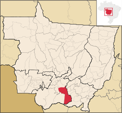
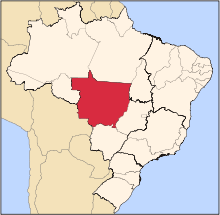
Santo Antônio do Leverger is a municipality in the southern part of the state of Mato Grosso, Brazil. The population is 18186 (2016 est.) in an area of 12,261.29 km².[1] Its elevation is 141 m.
The municipality contains the 1,487 hectares (3,670 acres) Águas Quentes State Park, the first protected area in Mato Grosso, which is known for the healing powers of its thermal waters.[2]
Population history
| Year | Population |
|---|
| 2004 | 15,459 |
| 2006 | 15,469 |
| 2015 | 19,257 |
External links
|
|---|
|
| Centro-Sul Mato-Grossense | | Alto Pantanal | |
|---|
| Alto Paraguai | |
|---|
| Cuiabá | |
|---|
| Rosario Oeste | |
|---|
| |
|---|
| Nordeste Mato-Grossense | | Canarana | |
|---|
| Medio Araguaia | |
|---|
| Norte Araguaia | |
|---|
|
|---|
| Norte Mato-Grossense | | Alta Floresta | |
|---|
| Alto Teles Pires | |
|---|
| Arinos | |
|---|
| Aripuanã | |
|---|
| Colíder | |
|---|
| Paranatinga | |
|---|
| Parecis | |
|---|
| Sinop | |
|---|
|
|---|
| Sudeste Mato-Grossense | | Alto Araguaia | |
|---|
| Primavera do Leste | |
|---|
| Rondonópolis | |
|---|
| Tesouro | |
|---|
|
|---|
| Sudoeste Mato-Grossense | | Alto Guapore | |
|---|
| Jauru | |
|---|
| Tangará da Serra | |
|---|
|
|---|