Sant'Angelo Lomellina
| Sant'Angelo Lomellina | |
|---|---|
| Comune | |
| Comune di Sant'Angelo Lomellina | |
 Sant'Angelo Lomellina Location of Sant'Angelo Lomellina in Italy | |
| Coordinates: 45°14′N 8°41′E / 45.233°N 8.683°ECoordinates: 45°14′N 8°41′E / 45.233°N 8.683°E | |
| Country | Italy |
| Region | Lombardy |
| Province | Province of Pavia (PV) |
| Area | |
| • Total | 10.4 km2 (4.0 sq mi) |
| Population (Dec. 2004) | |
| • Total | 821 |
| • Density | 79/km2 (200/sq mi) |
| Time zone | UTC+1 (CET) |
| • Summer (DST) | UTC+2 (CEST) |
| Postal code | 27030 |
| Dialing code | 0384 |
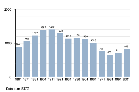
Sant'Angelo Lomellina is a comune (municipality) in the Province of Pavia in the Italian region Lombardy, located about 45 km southwest of Milan and about 35 km west of Pavia. As of 31 December 2004, it had a population of 821 and an area of 10.4 km².[1]
Sant'Angelo Lomellina borders the following municipalities: Castello d'Agogna, Castelnovetto, Ceretto Lomellina, Cozzo, Zeme.
Demographic evolution
References

This article is issued from
Wikipedia.
The text is licensed under Creative Commons - Attribution - Sharealike.
Additional terms may apply for the media files.