Lirio
| Lirio | |
|---|---|
| Comune | |
| Comune di Lirio | |
 Lirio Location of Lirio in Italy | |
| Coordinates: 45°0′N 9°15′E / 45.000°N 9.250°ECoordinates: 45°0′N 9°15′E / 45.000°N 9.250°E | |
| Country | Italy |
| Region | Lombardy |
| Province | Province of Pavia (PV) |
| Area | |
| • Total | 1.7 km2 (0.7 sq mi) |
| Population (Dec. 2004) | |
| • Total | 153 |
| • Density | 90/km2 (230/sq mi) |
| Time zone | UTC+1 (CET) |
| • Summer (DST) | UTC+2 (CEST) |
| Postal code | 27043 |
| Dialing code | 0385 |
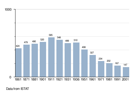
Lirio is a comune (municipality) in the Province of Pavia in the Italian region Lombardy, located about 50 km south of Milan and about 20 km southeast of Pavia. As of 31 December 2004, it had a population of 153 and an area of 1.7 km².[1]
Lirio borders the following municipalities: Montalto Pavese, Montecalvo Versiggia, Pietra de' Giorgi, Santa Maria della Versa.
Demographic evolution
References

This article is issued from
Wikipedia.
The text is licensed under Creative Commons - Attribution - Sharealike.
Additional terms may apply for the media files.