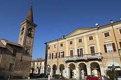
Casei Gerola
| Casei Gerola | |
|---|---|
| Comune | |
| Comune di Casei Gerola | |
 | |
 Casei Gerola Location of Casei Gerola in Italy | |
| Coordinates: 45°0′N 8°56′E / 45.000°N 8.933°ECoordinates: 45°0′N 8°56′E / 45.000°N 8.933°E | |
| Country | Italy |
| Region | Lombardy |
| Province | Pavia (PV) |
| Frazioni | Gerola |
| Government | |
| • Mayor | Ezio Stella |
| Area | |
| • Total | 24.8 km2 (9.6 sq mi) |
| Elevation | 81 m (266 ft) |
| Population (May. 2012)[1] | |
| • Total | 2,520 |
| • Density | 100/km2 (260/sq mi) |
| Demonym(s) | Casellesi |
| Time zone | UTC+1 (CET) |
| • Summer (DST) | UTC+2 (CEST) |
| Postal code | 27050 |
| Dialing code | 0383 |
| Website | www.comune.caseigerola.pv.it |
Casei Gerola is a comune (municipality) in the Province of Pavia in the Italian region Lombardy, located about 60 kilometres (37 mi) southwest of Milan and about 25 kilometres (16 mi) southwest of Pavia.
Casei Gerola borders the following municipalities: Bastida de' Dossi, Castelnuovo Scrivia, Cornale, Isola Sant'Antonio, Mezzana Bigli, Molino dei Torti, Pontecurone, Silvano Pietra, Voghera.
It was part of the Counties of Guastalla and, later, county of Montechiarugolo, both ruled by the Torelli family, until 1612. It remained to the Torelli until 1797.
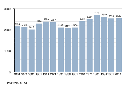
Demographic evolution
References

This article is issued from
Wikipedia.
The text is licensed under Creative Commons - Attribution - Sharealike.
Additional terms may apply for the media files.