Kami, Hyōgo (Mikata)
| Kami 香美町 | |||
|---|---|---|---|
| Town | |||
| |||
 Location of Kami in Hyōgo Prefecture | |||
 Kami Location in Japan | |||
| Coordinates: 35°38′N 134°38′E / 35.633°N 134.633°ECoordinates: 35°38′N 134°38′E / 35.633°N 134.633°E | |||
| Country | Japan | ||
| Region | Kansai | ||
| Prefecture | Hyōgo Prefecture | ||
| District | Mikata | ||
| Government | |||
| • Mayor | Hayato Hamagami | ||
| Area | |||
| • Total | 369.08 km2 (142.50 sq mi) | ||
| Population (May 1, 2017) | |||
| • Total | 18,396 | ||
| • Density | 50/km2 (130/sq mi) | ||
| Symbols | |||
| • Tree |
Fagus crenata Castanopsis | ||
| • Flower | Sakura | ||
| Time zone | UTC+9 (JST) | ||
| Website |
www | ||


Kami (香美町 Kami-chō) is a town located in Mikata District, Hyōgo Prefecture, Japan.
The town was formed on April 1, 2005 from the merger of the former town of Kasumi, from Kinosaki District, and the towns of Mikata and Muraoka, both from Mikata District.
As of May 1, 2017, the town has an estimated population of 18,396.[1] The total area is 369.08 km².
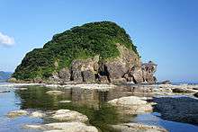
Kami lies entirely within the central part of San'in Kaigan Geopark.[2]
Geography
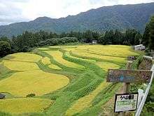
Kami Town consists of 3 wards; Kasumi (香住), Muraoka (村岡), and Ojiro (小代).
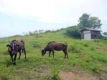
Ojiro is designated as one of the Most Beautiful Villages in Japan, and is the birthplace of Tajiri-go, a Tajima Cattle who is the ancestor of more than 99.9% of Japanese Black wagyu.
This town is also the location of the Amarube Bridge, a famous railroad trestle bridge, and of the Tajima Plateau Botanical Gardens.
Neighbouring municipalities
- Hyōgo Prefecture
- Tottori Prefecture
Transportation
Railway
Highways
Sister cities
References
- ↑ "Official website of Kami Town" (in Japanese). Japan: Kami Town. Retrieved 14 May 2017.
- ↑ "What is San'in Kaigan Geopark" on the official website of San'in Kaigan Geopark (in Japanese)
External links

- Kami official website (in Japanese)
| Wards of Kobe | ||
|---|---|---|
| Core cities | ||
| Special cities | ||
| Cities | ||
| Districts | ||