Dingras
| Dingras | ||
|---|---|---|
| Municipality | ||
| Municipality of Dingras | ||
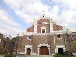 Facade of the church of Dingras | ||
| ||
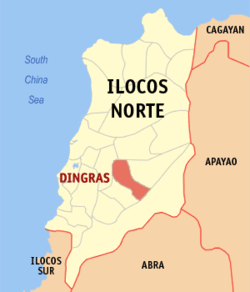 Map of Ilocos Norte with Dingras highlighted | ||
.svg.png) Dingras Location within the Philippines | ||
| Coordinates: 18°06′33″N 120°41′34″E / 18.10917°N 120.69278°ECoordinates: 18°06′33″N 120°41′34″E / 18.10917°N 120.69278°E | ||
| Country |
| |
| Region | Ilocos Region (Region I) | |
| Province | Ilocos Norte | |
| District | 2nd District | |
| Founded | 1598 | |
| Barangays | 31 (see Barangays) | |
| Government [1] | ||
| • Type | Sangguniang Bayan | |
| • Mayor | Erdio E. Valenzuela | |
| • Electorate | 23,828 voters (2016) | |
| Area [2] | ||
| • Total | 96.00 km2 (37.07 sq mi) | |
| Population (2015 census)[3] | ||
| • Total | 38,562 | |
| • Density | 400/km2 (1,000/sq mi) | |
| Time zone | UTC+8 (PST) | |
| ZIP code | 2913 | |
| PSGC | 012809000 | |
| IDD : area code | +63 (0)77 | |
| Climate type | Tropical monsoon climate | |
| Income class | 2nd municipal income class | |
| Revenue (₱) | 162,065,252.93 (2016) | |
| Native languages |
Ilocano Tagalog | |
| Website |
www | |

Dingras, officially the Municipality of Dingras, is a 2nd class municipality in the province of Ilocos Norte, Philippines. According to the 2015 census, it has a population of 38,562 people.[3]
The Municipality of Dingras has a total area of 17,962 hectares, ranking 8th in size among the 23 municipalities including Laoag City. It accounts for practically 5.2% of the total land area of Ilocos Norte and corresponding percentage to the municipal area composed of thirty one (31) barangays. Six (6) are on the Poblacion and twenty five (25) in the rural area. Out of the total area 6,305 hectares is devoted to rice and corn production. Other non-productive areas are devoted to livestock production, swine production and other livelihood projects. Most of the population are engaged in farming as the primary source of income.
Barangays
Dingras is politically subdivided into 31 barangays. [2]
| Brgy Name | Population (2010)[4] | Remarks |
|---|---|---|
| Albano | Poblacion | |
| Bacsil | ||
| Bagut | ||
| Parado | Bangay | |
| Baresbes | ||
| Barong | ||
| Bungcag | ||
| Cali | ||
| Capasan | ||
| Dancel | Poblacion | |
| Foz | ||
| San Marcos | ||
| Elizabeth | ||
| Francisco | Surrate | |
| Suyo | ||
| San Esteban | ||
| Espiritu | ||
| Sulquiano | Sidiran | |
| Guerrero | Poblacion | |
| Lanas | ||
| Lumbad | ||
| Madamba | Poblacion | |
| Mandaloque | ||
| Medina | ||
| Ver | Naglayaan | |
| San Marcelino | Padong | |
| Puruganan | Poblacion | |
| Peralta | Poblacion | |
| Root | Baldias | |
| Sagpatan | ||
| Saludares |
History
The Legend of DINGRAS
As in other communities, the town of Dingras has an interesting legend as to how its name evolved. The legend, as handed down from generation to generation, was classically romantic, a gallant heir - warrior fighting for a lady’s love.
In the early times, there were two prosperous barangays in the present site of the town each one ruled by a powerful chief or datu. They were bitter and mortal enemies. Naslag was the powerful chief of the barangay north of the river while Allawigan was the chief of the south of the river. One day, Allawigan and his warriors went to hunt. Rass, his son, was the bravest among them. During the hunt, Ras followed the deer, which went north across the river. While he was watching the fleeing deer, he saw a beautiful damsel gathering wild flowers on the opposite side of the riverbank. She was Ding, the daughter of Naslag. To help the lady, Ras gathered the most beautiful flowers near him; put them at the head of his arrow and shoot near the lady’s feet. Ding looked at the other side of the river and waved her hands. Ras went home happily.
Ras begged his father for permission to win Ding for his wife. But because the fathers of Ding and Ras were bitter enemies, the only way he could win her was in the open battle fiercely fought between the two tribes. Ras led his father’s warriors. They fought valiant and came out victorious in the end. Ras asked for Ding as a prize but Naslag refused. This angered him and hurled a challenge to the bravest warrior of Naslag in single combat with Ding as prize. The challenge was accepted. The combat was fought, and again, Ras was victorious. He brought Ding triumphantly to Allawigan, his father. Thereafter, the people named the two barangays Dingras, after Ras, their valiant warrior ruler, and Ding, his beautiful wife.
Demographics
| Population census of Dingras | ||
|---|---|---|
| Year | Pop. | ±% p.a. |
| 1903 | 15,792 | — |
| 1918 | 21,388 | +2.04% |
| 1939 | 22,434 | +0.23% |
| 1948 | 24,481 | +0.97% |
| 1960 | 28,308 | +1.22% |
| 1970 | 22,751 | −2.16% |
| 1975 | 25,530 | +2.34% |
| 1980 | 26,511 | +0.76% |
| 1990 | 30,519 | +1.42% |
| 1995 | 31,485 | +0.59% |
| 2000 | 33,310 | +1.22% |
| 2007 | 35,793 | +1.00% |
| 2010 | 37,021 | +1.24% |
| 2015 | 38,562 | +0.78% |
| Source: Philippine Statistics Authority[3] [4] [5] [6] | ||
In the 2015 census, the population of Dingras was 38,562 people,[3]
with a density of 400 inhabitants per square kilometre or 1,000 inhabitants per square mile.
Longest Bibingka
On October 9, 2007, Dingras, Ilocos Norte, Philippines eyed a "Guinness World Records" certification after baking a kilometer-long "bibingka" (native cake) made from 1,000 kilos of cassava and eaten by 1,000 residents.[7]
List of Cultural Properties of Dingras
| Cultural Property wmph identifier |
Site name | Description | Province | City/Municipality | Address/Location | Coordinates | Image |
|---|---|---|---|---|---|---|---|
| Versoza House Ruins | Destroyed by earthquake | Ilocos Norte | Dingras | Padawin Street, Brgy. Madamba, Poblacion, | 18°06′09″N 120°41′51″E / 18.102366°N 120.697444°E | 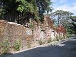 | |
| Silvino Madamba House | Ilocos Norte | Dingras | Brgy. Madamba | 18°06′10″N 120°41′50″E / 18.102799°N 120.697235°E | 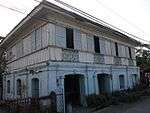 | ||
| Taylan House | Ilocos Norte | Dingras | Brgy. Madamba | 18°06′07″N 120°41′54″E / 18.101981°N 120.698360°E | 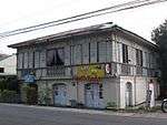 | ||
| Albano House | Ilocos Norte | Dingras | Brgy. Madamba | 18°06′06″N 120°41′55″E / 18.101802°N 120.698647°E | 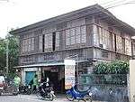 | ||
| St. Joseph Educational Center of Dingras | Built in the 1940s-1950s; formerly the parish church of Dingras | Ilocos Norte | Dingras | Brgy. Madamba | 18°06′08″N 120°41′56″E / 18.102133°N 120.698983°E | 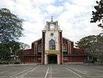 | |
| St. Joseph Parish Church of Dingras | Ilocos Norte | Dingras | Poblacion, Brgy. Madamba | 18°06′11″N 120°41′55″E / 18.102967°N 120.698733°E | 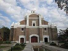 | ||
| Boy Scouts Monument | Ilocos Norte | Dingras | Poblacion, Brgy. Madamba | 18°06′09″N 120°41′54″E / 18.102450°N 120.698333°E |  | ||
| St. Joseph Institute of Dingras Building | Ilocos Norte | Dingras | Poblacion, Brgy. Madamba | 18°06′12″N 120°41′54″E / 18.103450°N 120.698417°E | 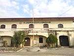 | ||
| Unknown House | Ilocos Norte | Dingras | Rang-ay, Brgy. Madamba | 18°06′14″N 120°41′50″E / 18.103966°N 120.697130°E |  | ||
| Puruganan Ancestral House | Currently used as Community Rural Bank of Dingras, with NHCP historical marker | Ilocos Norte | Dingras | Brgy. Madamba | 18°06′15″N 120°41′51″E / 18.104150°N 120.697385°E | 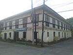 | |
| Josefa Llanes Escoda Monument | House where Josefa Llanes Escoda was born.[8] | Ilocos Norte | Dingras | Dona Josefa Llanes Escoda National Highway, Brgy. Madamba | 18°06′15″N 120°41′52″E / 18.104186°N 120.697669°E | 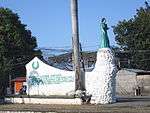 | |
| Dingras Cemetery | Ilocos Norte | Dingras | Dona Josefa Llanes Escoda National Highway, Brgy. Madamba | 18°06′53″N 120°41′32″E / 18.114681°N 120.692351°E | 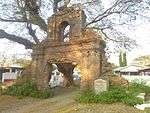 | ||
| Tabacalera de Dingras | Ilocos Norte | Dingras | Dona Josefa Llanes Escoda National Highway, Brgy. Madamba | 18°06′50″N 120°41′31″E / 18.113960°N 120.691828°E |  |
Notes
- ↑ "Municipality". Quezon City, Philippines: Department of the Interior and Local Government. Retrieved 31 May 2013.
- 1 2 "Province: Ilocos Norte". PSGC Interactive. Quezon City, Philippines: Philippine Statistics Authority. Retrieved 12 November 2016.
- 1 2 3 4 Census of Population (2015). "Region I (Ilocos Region)". Total Population by Province, City, Municipality and Barangay. PSA. Retrieved 20 June 2016.
- 1 2 Census of Population and Housing (2010). "Region I (Ilocos Region)". Total Population by Province, City, Municipality and Barangay. NSO. Retrieved 29 June 2016.
- ↑ Censuses of Population (1903–2007). "Region I (Ilocos Region)". Table 1. Population Enumerated in Various Censuses by Province/Highly Urbanized City: 1903 to 2007. NSO.
- ↑ "Province of Ilocos Norte". Municipality Population Data. Local Water Utilities Administration Research Division. Retrieved 17 December 2016.
- ↑ Abs-Cbn Interactive, Ilocos Norte town makes 'longest bibingka' Archived 2007-10-23 at the Wayback Machine.
- ↑ Dela Torre 2006, p. 174
Bibliography
- Dela Torre, Visitacion (2006). The Ilocos Heritage. Makati City: Tower Book House. ISBN 978-971-91030-9-7.