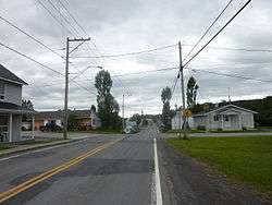
Sainte-Angèle-de-Mérici
| Sainte-Angèle-de-Mérici | |
|---|---|
| Municipality | |
 | |
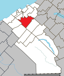 Location within La Mitis RCM | |
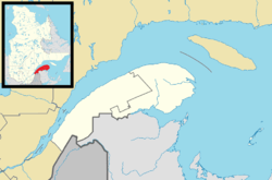 Ste-Angèle-de-Mérici Location in eastern Quebec | |
| Coordinates: 48°32′N 68°05′W / 48.53°N 68.08°WCoordinates: 48°32′N 68°05′W / 48.53°N 68.08°W[1] | |
| Country |
|
| Province |
|
| Region | Bas-Saint-Laurent |
| RCM | La Mitis |
| Constituted | April 26, 1989 |
| Government[2] | |
| • Mayor | Alain Carrier |
| • Federal riding | Haute-Gaspésie—La Mitis—Matane—Matapédia |
| • Prov. riding | Matane-Matapédia |
| Area[2][3] | |
| • Total | 107.30 km2 (41.43 sq mi) |
| • Land | 107.09 km2 (41.35 sq mi) |
| Population (2011)[3] | |
| • Total | 999 |
| • Density | 9.3/km2 (24/sq mi) |
| • Pop 2006–2011 |
|
| • Dwellings | 457 |
| Time zone | UTC−5 (EST) |
| • Summer (DST) | UTC−4 (EDT) |
| Postal code(s) | G0J 2H0 |
| Area code(s) | 418 and 581 |
| Highways |
|
| Website |
www.municipalite.sainte -angele-de-merici.qc.ca |
Sainte-Angèle-de-Mérici is a municipality in Quebec, Canada.
See also
References
External links

Adjacent Municipal Subdivisions | ||||||||||
|---|---|---|---|---|---|---|---|---|---|---|
| ||||||||||
| Cities & Towns | |
|---|---|
| Municipalities | |
| Parishes | |
| Villages | |
| Unorganized territories | |
| |
This article is issued from
Wikipedia.
The text is licensed under Creative Commons - Attribution - Sharealike.
Additional terms may apply for the media files.