Saint-Charles-Garnier, Quebec
| Saint-Charles-Garnier | |
|---|---|
| Parish municipality | |
.jpg) | |
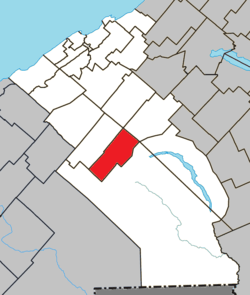 Location within La Mitis RCM | |
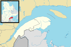 Saint-Charles-Garnier Location in eastern Quebec | |
| Coordinates: 48°20′N 68°03′W / 48.333°N 68.050°WCoordinates: 48°20′N 68°03′W / 48.333°N 68.050°W[1] | |
| Country |
|
| Province |
|
| Region | Bas-Saint-Laurent |
| RCM | La Mitis |
| Constituted | January 1, 1966 |
| Named for | Charles Garnier[1] |
| Government[2] | |
| • Mayor | Jean-Pierre Bélanger |
| • Federal riding | Haute-Gaspésie—La Mitis—Matane—Matapédia |
| • Prov. riding | Matane-Matapédia |
| Area[2][3] | |
| • Total | 84.80 km2 (32.74 sq mi) |
| • Land | 85.07 km2 (32.85 sq mi) |
| There is an apparent contradiction between two authoritative sources | |
| Population (2011)[3] | |
| • Total | 271 |
| • Density | 3.2/km2 (8/sq mi) |
| • Pop 2006-2011 |
|
| • Dwellings | 149 |
| Postal code(s) | G0K 1K0 |
| Area code(s) | 418 and 581 |
| Highways |
|
| Website |
www.municipalite. saint-charles-garnier.qc.ca |
Saint-Charles-Garnier is a parish municipality in Quebec, Canada.
See also
References
External links

Adjacent Municipal Subdivisions | ||||||||||
|---|---|---|---|---|---|---|---|---|---|---|
| ||||||||||
| Cities & Towns | |
|---|---|
| Municipalities | |
| Parishes | |
| Villages | |
| Unorganized territories | |
| |
This article is issued from
Wikipedia.
The text is licensed under Creative Commons - Attribution - Sharealike.
Additional terms may apply for the media files.