Rivière-du-Loup Regional County Municipality
| Rivière-du-Loup | |
|---|---|
| Regional county municipality | |
 | |
| Coordinates: 47°54′N 69°20′W / 47.900°N 69.333°WCoordinates: 47°54′N 69°20′W / 47.900°N 69.333°W[1] | |
| Country |
|
| Province |
|
| Region | Bas-Saint-Laurent |
| Effective | January 1, 1982 |
| County seat | Rivière-du-Loup |
| Government[2] | |
| • Type | Prefecture |
| • Prefect | Michel Lagacé |
| Area[2][3] | |
| • Total | 1,768.20 km2 (682.71 sq mi) |
| • Land | 1,273.46 km2 (491.69 sq mi) |
| Population (2011)[3] | |
| • Total | 34,375 |
| • Density | 27.0/km2 (70/sq mi) |
| • Pop 2006-2011 |
|
| • Dwellings | 16,779 |
| Time zone | UTC−5 (EST) |
| • Summer (DST) | UTC−4 (EDT) |
| Area code(s) | 418 and 581 |
| Website |
www |
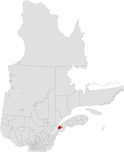
Rivière-du-Loup is a regional county municipality in the Bas-Saint-Laurent region of Quebec, Canada. Its most important city is Rivière-du-Loup, which contains more than half of the population.
Major industries include pulp and paper, other wood products, peat products, mineral products and textiles.
The name comes from the French, "River of the Wolf".
Subdivisions
There are 13 subdivisions and one native reserve within the RCM:[2]
|
|
|
|
Transportation
Access Routes
Highways and numbered routes that run through the municipality, including external routes that start or finish at the county border:[4]
|
|
|
|
See also
References
Adjacent Counties & Equivalent Territories | |
|---|---|
| Regional county municipalities and equivalent territories | |
|---|---|
| Municipalities | |
This article is issued from
Wikipedia.
The text is licensed under Creative Commons - Attribution - Sharealike.
Additional terms may apply for the media files.