Lac-à-la-Croix, Quebec
| Lac-à-la-Croix | |
|---|---|
| Unorganized Territory | |
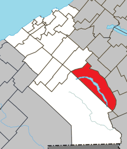
 Location within La Mitis RCM | |
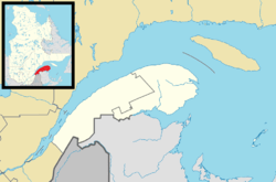
 Lac-à-la-Croix Location in eastern Quebec | |
| Coordinates: 48°18′N 67°47′W / 48.3°N 67.78°WCoordinates: 48°18′N 67°47′W / 48.3°N 67.78°W[1] | |
| Country |
|
| Province |
|
| Region | Bas-Saint-Laurent |
| RCM | La Mitis |
| Established | January 1, 1986 |
| Government[2] | |
| • Federal riding | Haute-Gaspésie—La Mitis—Matane—Matapédia |
| • Prov. riding | Matane-Matapédia |
| Area[2][3] | |
| • Total | 240.50 km2 (92.86 sq mi) |
| • Land | 224.46 km2 (86.66 sq mi) |
| Population (2011)[3] | |
| • Total | 0 |
| • Density | 0.0/km2 (0/sq mi) |
| • Pop 2006-2011 |
|
| • Dwellings | 0 |
| Time zone | UTC−5 (EST) |
| • Summer (DST) | UTC−4 (EDT) |
| Area code(s) | 418 and 581 |
| Highways | No major routes |
Lac-à-la-Croix is an unorganized territory in the Canadian province of Quebec, located in the La Mitis Regional County Municipality.
See also
References
This article is issued from
Wikipedia.
The text is licensed under Creative Commons - Attribution - Sharealike.
Additional terms may apply for the media files.