Saint Patrick Parish, New Brunswick
| Saint Patrick St. Patrick | |
|---|---|
| Parish | |
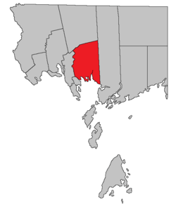 Location within Charlotte County. | |
| Country |
|
| Province |
|
| County | Charlotte County |
| Established | 1756 |
| Area[1] | |
| • Land | 236.88 km2 (91.46 sq mi) |
| Population (2011)[1] | |
| • Total | 647 |
| • Density | 2.7/km2 (7/sq mi) |
| • Pop 2006-2011 |
|
| • Dwellings | 349 |
| Time zone | UTC-4 (AST) |
| • Summer (DST) | UTC-3 (ADT) |
Saint Patrick is a Canadian parish in Charlotte County, New Brunswick.[2]
History
Saint Patrick Parish was established in 1786; it included Dumbarton Parish until 1856.
Delineation
Saint Patrick Parish is defined in the Territorial Division Act[3] as being bounded:
- West and northwest by Saint Andrews Parish and Saint Croix Parish; east by the west line of the grant to Philip Bailey and others, and its northerly prolongation; north by a line commencing at the most southern angle of lot number five, granted to John Gilman, on the southwestern side of Digdeguash River; thence northeasterly along the southeasterly line of said lot to the Digdeguash River; thence down stream along the same to the lower line of the lot granted to John Campbell; thence along the same easterly to the rear thereof; thence northerly along the rear of the said last mentioned lot to meet the westerly prolongation of the line dividing the lots ten and eleven in the Clarence Hill grant plan, and thence easterly along the said line dividing the lots number ten and number eleven to the eastern boundary of the parish; and south by Passamaquoddy bay, including all the islands west of the east line of the said parish within two miles of the shore.
Governance
The entire parish forms the local service district of the parish of Saint Patrick,[lower-alpha 1] established in 1970 to assess for fire protection. First aid and ambulance services were added in 1975.
Communities
Parish population total does not include incorporated municipalities (in bold).
|
|
|
Bodies of water & Islands
This is a list of rivers, lakes, streams, creeks, marshes and Islands that are at least partially in this parish
|
|
|
Demographics
Population
| Canada census – Saint Patrick Parish, New Brunswick community profile | |||
|---|---|---|---|
| 2011 | 2006 | ||
| Population: | 647 (-10.3% from 2006) | 721 (+6.5% from 2001) | |
| Land area: | 236.88 km2 (91.46 sq mi) | 236.76 km2 (91.41 sq mi) | |
| Population density: | 2.7/km2 (7.0/sq mi) | 3.0/km2 (7.8/sq mi) | |
| Median age: | 48.5 (M: 50.1, F: 47.8) | 44.3 (M: 45.9, F: 43.1) | |
| Total private dwellings: | 349 | 526 | |
| Median household income: | $.N/A | $43,854 | |
| Notes: 2011 income data for this area has been suppressed for data quality or confidentiality reasons. – References: 2011[1] 2006[4] earlier[5] | |||
| Historical Census Data - Saint Patrick Parish, New Brunswick[6] | ||||||||||||||||||||||||||
|---|---|---|---|---|---|---|---|---|---|---|---|---|---|---|---|---|---|---|---|---|---|---|---|---|---|---|
|
|
| ||||||||||||||||||||||||
Language
| Canada Census Mother Tongue - Saint Patrick Parish, New Brunswick[6] | ||||||||||||||||||
|---|---|---|---|---|---|---|---|---|---|---|---|---|---|---|---|---|---|---|
| Census | Total | English |
French |
English & French |
Other | |||||||||||||
| Year | Responses | Count | Trend | Pop % | Count | Trend | Pop % | Count | Trend | Pop % | Count | Trend | Pop % | |||||
2011 |
645 |
625 | 96.90% | 15 | 2.33% | 0 | 0.00% | 5 | 0.77% | |||||||||
2006 |
715 |
700 | 97.90% | 15 | 2.10% | 0 | 0.00% | 0 | 0.00% | |||||||||
2001 |
670 |
645 | 96.27% | 0 | 0.00% | 10 | 1.49% | 15 | 2.24% | |||||||||
1996 |
640 |
610 | n/a | 95.31% | 0 | n/a | 0.00% | 0 | n/a | 0.00% | 30 | n/a | 4.69% | |||||
Access Routes
Highways and numbered routes that run through the parish, including external routes that start or finish at the parish limits:[7]
See also
Footnotes
- ↑ The name was originally styled St. Patrick in English and St-Patrick in French (1984); it was changed to the modern form in 1985.
References
- 1 2 3 "2011 Community Profiles". Canada 2011 Census. Statistics Canada. July 5, 2013. Retrieved 2014-03-17.
- ↑ New Brunswick Provincial Archives - Saint Patrick Parish
- ↑ "Territorial Division Act (R.S.N.B. 1973, c. T-3)". Government of New Brunswick website. Retrieved 25 August 2016.
- ↑ "2006 Community Profiles". Canada 2006 Census. Statistics Canada. March 30, 2011. Retrieved 2014-03-17.
- ↑ "2001 Community Profiles". Canada 2001 Census. Statistics Canada. February 17, 2012.
- 1 2 Statistics Canada: 1996, 2001, 2006, 2011 census
- ↑ Atlantic Canada Back Road Atlas ISBN 978-1-55368-618-7 Pages 4, 12
Places adjacent to Saint Patrick Parish, New Brunswick | ||||||||||
|---|---|---|---|---|---|---|---|---|---|---|
| ||||||||||
| Subdivisions | |
|---|---|
| Cities | |
| Counties | |
| |
Coordinates: 45°16′39″N 67°04′08″W / 45.277544°N 67.068787°W