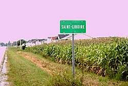
Saint-Liboire, Quebec
| Saint-Liboire | |
|---|---|
| Municipality | |
 | |
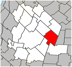 Location within Les Maskoutains RCM | |
 Saint-Liboire Location in southern Quebec | |
| Coordinates: 45°39′N 72°46′W / 45.650°N 72.767°WCoordinates: 45°39′N 72°46′W / 45.650°N 72.767°W[1] | |
| Country |
|
| Province |
|
| Region | Montérégie |
| RCM | Les Maskoutains |
| Settled | 1710 |
| Constituted | August 17, 1994 |
| Government[2][3] | |
| • Mayor | Denis Chabot |
| • Federal riding | Saint-Hyacinthe—Bagot |
| • Prov. riding | Saint-Hyacinthe |
| Area[2][4] | |
| • Total | 75.20 km2 (29.03 sq mi) |
| • Land | 72.74 km2 (28.09 sq mi) |
| Population (2011)[4] | |
| • Total | 3,051 |
| • Density | 41.9/km2 (109/sq mi) |
| • Pop 2006-2011 |
|
| • Dwellings | 1,107 |
| Time zone | UTC−5 (EST) |
| • Summer (DST) | UTC−4 (EDT) |
| Postal code(s) | J0H 1R0 |
| Area code(s) | 450 and 579 |
| Highways |
|
| Geocode | 54072 |
| People | Liboirois, Liboiroise |
| Website |
www.municipalite. st-liboire.qc.ca |
Saint-Liboire (or Saint-Liboire-de-Bagot) is a municipality in the municipalité régionale de comté des Maskoutains in Québec (Canada), located in the administrative region of Montérégie. The population as of the Canada 2011 Census was 3,051.
History
Before the foundation of Saint-Liboire, the actual town territory was included in the Seigneurie de Ramezay given to Claude de Ramezay near 1710.
The village municipality was founded in 1857 with the purpose to offer more arable lands to the Catholic colonists coming from the Saint-Hyacinthe region.
It became the chief town of Bagot County.
Reading Suggestion
Historians will be fascinated by the book Centenaire de Saint-Liboire, 20-24 juin 1957 : album-souvenir, 1857-1957 written by Dollard Boucher and Armand Laliberté. This book is available at the Bibliothèque et Archives nationales du Québec.
Demographics
Population
| Canada census – Saint-Liboire, Quebec community profile | |||
|---|---|---|---|
| 2011 | 2006 | ||
| Population: | 3,051 (+5.4% from 2006) | 2,895 (+2.3% from 2001) | |
| Land area: | 72.74 km2 (28.09 sq mi) | 72.74 km2 (28.09 sq mi) | |
| Population density: | 41.9/km2 (109/sq mi) | 39.8/km2 (103/sq mi) | |
| Median age: | 34.7 (M: 34.4, F: 34.9) | 33.9 (M: 33.6, F: 34.3) | |
| Total private dwellings: | 1,107 | 1,089 | |
| Median household income: | $58,991 | $51,375 | |
| References: 2011[4] 2006[5] earlier[6] | |||
| Historical Census Data - Saint-Liboire, Quebec[7] | ||||||||||||||||||||||||||
|---|---|---|---|---|---|---|---|---|---|---|---|---|---|---|---|---|---|---|---|---|---|---|---|---|---|---|
|
|
| ||||||||||||||||||||||||
Language
| Canada Census Mother Tongue - Saint-Liboire, Quebec[7] | ||||||||||||||||||
|---|---|---|---|---|---|---|---|---|---|---|---|---|---|---|---|---|---|---|
| Census | Total | French |
English |
French & English |
Other | |||||||||||||
| Year | Responses | Count | Trend | Pop % | Count | Trend | Pop % | Count | Trend | Pop % | Count | Trend | Pop % | |||||
2011 |
3,040 |
3,010 | 99.01% | 10 | 0.33% | 0 | 0.00% | 20 | 0.66% | |||||||||
2006 |
2,915 |
2,870 | 98.46% | 15 | 0.51% | 0 | 0.00% | 30 | 1.03% | |||||||||
2001 |
2,815 |
2,755 | 97.87% | 20 | 0.71% | 10 | 0.35% | 30 | 1.07% | |||||||||
1996 |
2,580 |
2,540 | n/a | 98.45% | 25 | n/a | 0.97% | 0 | n/a | 0.00% | 15 | n/a | 0.58% | |||||
See also
References
- ↑ Reference number 291641 of the Commission de toponymie du Québec (in French)
- 1 2 "Ministère des Affaires municipales, des Régions et de l'Occupation du territoire: Saint-Liboire". Archived from the original on 2015-12-12. Retrieved 2012-03-11.
- ↑ Parliament of Canada Federal Riding History: SAINT-HYACINTHE--BAGOT (Quebec)
- 1 2 3 "2011 Community Profiles". Canada 2011 Census. Statistics Canada. July 5, 2013. Retrieved 2014-03-22.
- ↑ "2006 Community Profiles". Canada 2006 Census. Statistics Canada. March 30, 2011. Retrieved 2014-03-22.
- ↑ "2001 Community Profiles". Canada 2001 Census. Statistics Canada. February 17, 2012.
- 1 2 Statistics Canada: 1996, 2001, 2006, 2011 census
External links
| Wikimedia Commons has media related to Saint-Liboire. |
- [http://demers.mine.nu/ftproot/Saint-Liboire.kmz KMZ File working] with Google Earth.
- Informations on Saint-Liboire
- Details on the town
- Photos of the Saint-Patrice Street (July 2003), Patrice Marcotte
- Page on Quebec Municipal
Adjacent Municipal Subdivisions | |
|---|---|
| Cities | |
|---|---|
| Municipalities | |
| Parishes | |
| Villages | |
| |