Saint-Georges, French Guiana
| Saint-Georges | |
|---|---|
| Commune | |
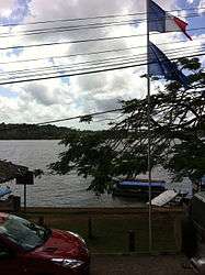 A view across the river from the French side | |
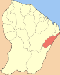 Location of the commune (in red) within French Guiana | |
| Coordinates: 3°53′20″N 51°48′04″W / 3.8889°N 51.8012°WCoordinates: 3°53′20″N 51°48′04″W / 3.8889°N 51.8012°W | |
| Country | France |
| Overseas region and department | French Guiana |
| Arrondissement | Cayenne |
| Canton | Saint-Georges-de-l'Oyapock |
| Intercommunality | Est Guyanais |
| Government | |
| • Mayor (2014-2020) | Georges Elfort (DVG) |
| Area1 | 2,320 km2 (900 sq mi) |
| Population (2012)2 | 3,855 |
| • Density | 1.7/km2 (4.3/sq mi) |
| INSEE/Postal code | 97308 /97313 |
|
1 French Land Register data, which excludes lakes, ponds, glaciers > 1 km2 (0.386 sq mi or 247 acres) and river estuaries. 2 Population without double counting: residents of multiple communes (e.g., students and military personnel) only counted once. | |
Saint-Georges (sometimes unofficially called Saint-Georges-de-l'Oyapock) is a commune of French Guiana, an overseas region and department of France located in South America. It lies on the Oyapock River (which forms the border with Brazil), opposite the Brazilian town of Oiapoque. The town contains a town hall, a French Foreign Legion detachment and some hotels (the main ones being Le Tamarin, Coz Calè and the Chez Modestine).
An asphalted road from Saint-Georges to Régina was opened in 2004, completing the road from Cayenne (the préfecture and largest city of French Guiana) to the Brazilian border and ending the isolation of Saint-Georges. It is now possible to drive on a fully paved road from Saint-Laurent-du-Maroni on the Surinamese border to Saint-Georges on the Brazilian border.
Following an international treaty between France and Brazil signed in July 2005, the Oyapock River Bridge was built and was opened in March 2017. This bridge is the first land crossing ever opened between France and Brazil, and indeed between French Guiana and the rest of the world (there exists no other bridge crossing the Oyapock River, and no bridge crossing the Maroni River marking the border with Suriname). When the bridge was opened, it is possible to drive uninterrupted from Cayenne to Macapá (on the Amazon River), the capital of the state of Amapá in Brazil.
See also
References
External links
| Wikimedia Commons has media related to Saint-Georges-de-l'Oyapock. |