Oyapock
The Oyapock or Oiapoque River (/ˈɔɪ.əpɒk,
Course
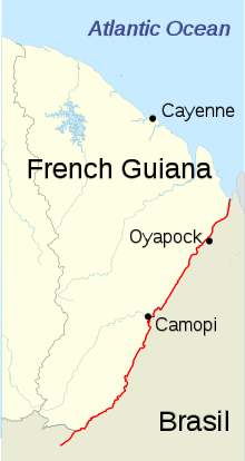
The Oyapock runs through the Guianan moist forests ecoregion.[2] It rises in the Tumuk Humak (Portuguese: Tumucumaque) mountain range and flows into the Atlantic Ocean, where its estuary forms a large bay bordering on Cape Orange.
The mouth of the Oyapock is the northern end of Brazil's coastline, as it is where the border between Brazil and French Guiana meets the ocean, but nearby Cape Orange, which separates the Bay of Oyapock from the Atlantic Ocean, is the northernmost point of the Brazilian coast. In Brazil, both the cape and the mouth of the Oyapock are often mistaken for the whole country's northernmost point (rather than just of its coastline), and in the past this information could even be found in geography schoolbooks.[3] Yet the true northernmost point in Brazil is actually far inland, on Monte Caburaí, in the state of Roraima, hundreds of kilometers from the Oyapock and almost a full degree more to the north.[3]
History
Vicente Yáñez Pinzón was said to be the first European person to see the Oiapoque River in the first years of the 16th century.[4] It has been rendered Japoc, Yapoc, Iapoco, Wiapoco, and even called the Vicente Pinzón River. Early European colonists referred to the river as the Wiapoco, and it was the site of early settlements by Briton Robert Harcourt in 1608 and Dutchman Jan van Ryen in 1627. The name Oiapoque has been officially used from 1900, when a territorial dispute between Brazil and France was resolved through Swiss diplomatic arbitration.
Settlements
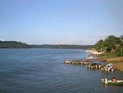
In addition to the small towns of Oiapoque (Brazil) and Saint-Georges de l'Oyapock (French Guiana), there are some small villages scattered along the bank of the Oyapock, such as Camopi and Clevelândia do Norte.
Bridge
The Oyapock River Bridge has been built across the river to connect the Brazilian town of Oiapoque and the French town of Saint-Georges de l'Oyapock. It is the first international land border connection of French Guiana, but although completed since 2011, as of February 2017 it remains closed to traffic, due to delays in making the final payments to the construction company, building and staffing the Brazilian customs facilities, and some minor disagreements between the Brazilian and French governments.[5] A 24-hour test opening was scheduled for 16 January 2017.[6]
In popular culture
The widespread Brazilian Portuguese expression "do Oiapoque ao Chuí" ("from the Oyapock to the Chuí [rivers]") is used to refer to the whole nation, by mentioning the waterways that mark respectively the northern and southern extremities of the Brazilian coastline (as noted above, they are often mistaken for the entire country's northern and southern extreme points). Thus, the saying is used in the same way as Americans use the expression "from coast to coast."
See also
References
- ↑ "Oyapock: the bridge to discord?". France 24. 2012-09-07. Retrieved 2014-04-13.
- ↑ Schipper, Jan; Teunissen, Pieter; Lim, Burton, Northern South America: Guyana, Suriname, French Guiana, northern Brazil, and eastern Venezuela (NT0125), retrieved 2017-04-03
- 1 2 "Expedição ao Monte Caburaí, extremo Norte de RR, completa 17 anos" [Expedition to Mount Caburaí, northernmost point of Roraima, was 17 years ago]. G1 (in Portuguese). 2015-09-08. Retrieved 2017-02-28.
- ↑ "Ornamental Garden Plants Of Th Guianas" (PDF). Wilderness-explorers. Retrieved 2014-04-13.
- ↑ Lissardy, Gerardo (2016-01-03). "A ponte entre Brasil e Guiana Francesa que ninguém pode cruzar" [The bridge between Brazil and French Guiana that nobody can cross]. BBC Brasil (in Portuguese). Retrieved 2017-02-28.
- ↑ "Ouverture-test du pont de l'Oyapock pour 24h le 16 janvier 2017" [Test opening of the Oyapock Bridge for 24 hours on January 16, 2017]. Radio Peyi (in French). Cayenne. 2016-12-06. Retrieved 2017-02-28.