Saint-Ferréol, Haute-Savoie
| Saint-Ferréol | ||
|---|---|---|
| Commune | ||
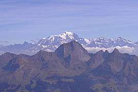 Mont Charvin, with Mont Blanc beyond, seen from Saint-Ferréol | ||
| ||
 Saint-Ferréol Location within Auvergne-Rhône-Alpes region  Saint-Ferréol | ||
| Coordinates: 45°46′00″N 6°18′27″E / 45.7667°N 6.3075°ECoordinates: 45°46′00″N 6°18′27″E / 45.7667°N 6.3075°E | ||
| Country | France | |
| Region | Auvergne-Rhône-Alpes | |
| Department | Haute-Savoie | |
| Arrondissement | Arrondissement of Annecy | |
| Canton | Canton of Faverges | |
| Intercommunality | C.C. des Sources du Lac d'Annecy | |
| Government | ||
| • Mayor (2014–2020) | Philippe Prud'Homme | |
| Area1 | 16.79 km2 (6.48 sq mi) | |
| Population (2014)2 | 817 | |
| • Density | 49/km2 (130/sq mi) | |
| Demonym(s) | Ferréolains | |
| Time zone | UTC+1 (CET) | |
| • Summer (DST) | UTC+2 (CEST) | |
| INSEE/Postal code | 74234 /74210 | |
| Elevation | 479–2,038 m (1,572–6,686 ft) | |
|
1 French Land Register data, which excludes lakes, ponds, glaciers > 1 km2 (0.386 sq mi or 247 acres) and river estuaries. 2 Population without double counting: residents of multiple communes (e.g., students and military personnel) only counted once. | ||

Saint-Ferréol is a commune in the Haute-Savoie department in the Auvergne-Rhône-Alpes region in south-eastern France.
See also
References
| Wikimedia Commons has media related to Saint-Ferréol. |
This article is issued from
Wikipedia.
The text is licensed under Creative Commons - Attribution - Sharealike.
Additional terms may apply for the media files.