Yvoire
| Yvoire | ||
|---|---|---|
| Commune | ||
 The medieval gate | ||
| ||
 Yvoire Location within Auvergne-Rhône-Alpes region  Yvoire | ||
| Coordinates: 46°22′18″N 6°19′37″E / 46.3716°N 6.327°ECoordinates: 46°22′18″N 6°19′37″E / 46.3716°N 6.327°E | ||
| Country | France | |
| Region | Auvergne-Rhône-Alpes | |
| Department | Haute-Savoie | |
| Arrondissement | Thonon-les-Bains | |
| Canton | Sciez | |
| Intercommunality | Thonon Agglomération | |
| Government | ||
| • Mayor (2014-2020) | Jean-François Kung | |
| Area1 | 3.12 km2 (1.20 sq mi) | |
| Population (2014)2 | 925 | |
| • Density | 300/km2 (770/sq mi) | |
| Time zone | UTC+1 (CET) | |
| • Summer (DST) | UTC+2 (CEST) | |
| INSEE/Postal code | 74315 /74140 | |
| Elevation | 372–441 m (1,220–1,447 ft) | |
|
1 French Land Register data, which excludes lakes, ponds, glaciers > 1 km2 (0.386 sq mi or 247 acres) and river estuaries. 2 Population without double counting: residents of multiple communes (e.g., students and military personnel) only counted once. | ||

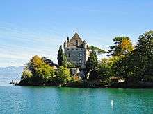
Yvoire is a small medieval town in the department of Haute-Savoie, in the southeastern French region of Auvergne-Rhône-Alpes.
Geography
Located at the tip of the Leman peninsula (presqu'île de Léman), Yvoire delimits the two main parts of Lake Geneva, the "petit lac" and the "grand lac".
Features
The town is well known for its medieval buildings and summer floral displays, as well as the Jardin des Cinq Sens, a garden in the center of the town. It is called one of the "most beautiful villages of France".
History
The town was fortified by Amadeus V in the 14th century. It soon gained a strategic military importance and the inhabitants were given tax privileges.
See also
References
External links
| Wikimedia Commons has media related to Yvoire. |
| Authority control |
|---|