Le Biot
| Le Biot | ||
|---|---|---|
| Commune | ||
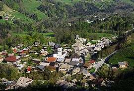 Le Biot seen from above | ||
| ||
 Le Biot Location within Auvergne-Rhône-Alpes region  Le Biot | ||
| Coordinates: 46°15′48″N 6°37′59″E / 46.2633°N 6.6331°ECoordinates: 46°15′48″N 6°37′59″E / 46.2633°N 6.6331°E | ||
| Country | France | |
| Region | Auvergne-Rhône-Alpes | |
| Department | Haute-Savoie | |
| Arrondissement | Thonon-les-Bains | |
| Canton | Évian-les-Bains | |
| Intercommunality | Communauté de communes de la Vallée d'Aulps | |
| Government | ||
| • Mayor (2014–2020) | Henri-Victor Tournier | |
| Area1 | 13.18 km2 (5.09 sq mi) | |
| Population (2014)2 | 546 | |
| • Density | 41/km2 (110/sq mi) | |
| Time zone | UTC+1 (CET) | |
| • Summer (DST) | UTC+2 (CEST) | |
| INSEE/Postal code | 74034 /74430 | |
| Elevation | 660–1,870 m (2,170–6,140 ft) | |
|
1 French Land Register data, which excludes lakes, ponds, glaciers > 1 km2 (0.386 sq mi or 247 acres) and river estuaries. 2 Population without double counting: residents of multiple communes (e.g., students and military personnel) only counted once. | ||

Le Biot is a commune in the Haute-Savoie department in the Auvergne-Rhône-Alpes region in south-eastern France.
See also
References
| Wikimedia Commons has media related to Le Biot. |
This article is issued from
Wikipedia.
The text is licensed under Creative Commons - Attribution - Sharealike.
Additional terms may apply for the media files.