Saint-Blaise, Haute-Savoie
| Saint-Blaise | |
|---|---|
| Commune | |
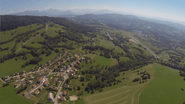 An aerial view of Saint-Blaise | |
 Saint-Blaise Location within Auvergne-Rhône-Alpes region  Saint-Blaise | |
| Coordinates: 46°03′58″N 6°05′22″E / 46.0661°N 6.0894°ECoordinates: 46°03′58″N 6°05′22″E / 46.0661°N 6.0894°E | |
| Country | France |
| Region | Auvergne-Rhône-Alpes |
| Department | Haute-Savoie |
| Arrondissement | Saint-Julien-en-Genevois |
| Canton | La Roche-sur-Foron |
| Intercommunality | Communauté de communes de Cruseilles |
| Government | |
| • Mayor (2008–2020) | Christine Megevand |
| Area1 | 2.55 km2 (0.98 sq mi) |
| Population (2014)2 | 353 |
| • Density | 140/km2 (360/sq mi) |
| Time zone | UTC+1 (CET) |
| • Summer (DST) | UTC+2 (CEST) |
| INSEE/Postal code | 74228 /74350 |
| Elevation | 760–1,188 m (2,493–3,898 ft) |
|
1 French Land Register data, which excludes lakes, ponds, glaciers > 1 km2 (0.386 sq mi or 247 acres) and river estuaries. 2 Population without double counting: residents of multiple communes (e.g., students and military personnel) only counted once. | |
Saint-Blaise is a commune in the Haute-Savoie department in the Auvergne-Rhône-Alpes region in south-eastern France.
See also
References
| Wikimedia Commons has media related to Saint-Blaise (Haute-Savoie). |
This article is issued from
Wikipedia.
The text is licensed under Creative Commons - Attribution - Sharealike.
Additional terms may apply for the media files.