Rupakot Gulmi
| Rupakot Gulmi रूपाकोट गुल्मी | |
|---|---|
| Village Development Committee | |
 | |
| Coordinates: 28°4′N 83°22′E / 28.067°N 83.367°ECoordinates: 28°4′N 83°22′E / 28.067°N 83.367°E | |
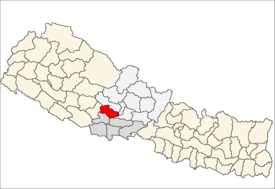
| Country | Nepal |
| Zone | Lumbini Zone |
| District | Gulmi District |
| Government | |
| • Type | Democratic |
| Population (1991) | |
| • Total | 3,521 |
| • Literacy | 90.2% |
| Time zone | UTC+5:45 (Nepal Time) |
| A.O.P. (Area Post Office) | 32604 |
| Area code(s) | 079 |
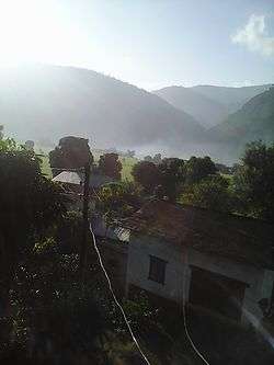
Rupakot is a Village Development Committee (VDC) in Gulmi District in the Lumbini Zone of central Nepal. Its headquarters is in Myal pokhara. It is located in about the center of Gulmi District. It is surrounded by hills. Its main religion is Hinduism. There are many temples like Chhatra Thaan, Shiddababa temple, Shiva Temple, Ram Temple,Debi deurali temple etc. The main sources of revenue for the village are agriculture and foreign employment. At the time of the 2001 Nepal census, it had a population of 3521 persons residing in 704 individual households. 76.48% of students attend school. The most populated parts of this VDC is Damuka, Sota & Ekle Pipal.[1]
References
- ↑ "Nepal Census 2001". Nepal's Village Development Committees. Digital Himalaya. Retrieved September 15, 2008.
This article is issued from
Wikipedia.
The text is licensed under Creative Commons - Attribution - Sharealike.
Additional terms may apply for the media files.