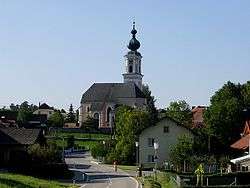
Rottenbach, Austria
| Rottenbach | ||
|---|---|---|
 | ||
| ||
 Rottenbach Location within Austria
Location in the district
| ||
| Coordinates: 48°12′22″N 13°40′52″E / 48.20611°N 13.68111°ECoordinates: 48°12′22″N 13°40′52″E / 48.20611°N 13.68111°E | ||
| Country | Austria | |
| State | Upper Austria | |
| District | Grieskirchen | |
| Government | ||
| • Mayor | Roman Anzengruber (ÖVP) | |
| Area | ||
| • Total | 14.6 km2 (5.6 sq mi) | |
| Elevation | 424 m (1,391 ft) | |
| Population (14 June 2016)[1] | ||
| • Total | 1,073 | |
| • Density | 73/km2 (190/sq mi) | |
| Time zone | UTC+1 (CET) | |
| • Summer (DST) | UTC+2 (CEST) | |
| Postal code | 4681 | |
| Area code | 07732 | |
| Vehicle registration | GR | |
| Website | www.rottenbach.gv.at | |
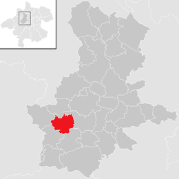
Rottenbach is a municipality in the district of Grieskirchen in the Austrian state of Upper Austria.
Geography
Rottenbach lies in the Hausruckviertel. About 10 percent of the municipality is forest, and 82 percent is farmland.
References
This article is issued from
Wikipedia.
The text is licensed under Creative Commons - Attribution - Sharealike.
Additional terms may apply for the media files.