Hofkirchen an der Trattnach
| Hofkirchen an der Trattnach | ||
|---|---|---|
 | ||
| ||
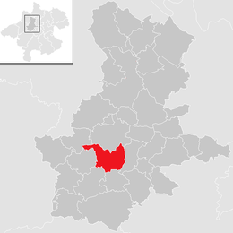
 Hofkirchen an der Trattnach Location within Austria
Location in the district
| ||
| Coordinates: 48°13′11″N 13°44′24″E / 48.21972°N 13.74000°ECoordinates: 48°13′11″N 13°44′24″E / 48.21972°N 13.74000°E | ||
| Country | Austria | |
| State | Upper Austria | |
| District | Grieskirchen | |
| Government | ||
| • Mayor | Alois Zauner (ÖVP) | |
| Area | ||
| • Total | 18 km2 (7 sq mi) | |
| Elevation | 389 m (1,276 ft) | |
| Population (14 June 2016)[1] | ||
| • Total | 1,640 | |
| • Density | 91/km2 (240/sq mi) | |
| Time zone | UTC+1 (CET) | |
| • Summer (DST) | UTC+2 (CEST) | |
| Postal code | 4716 | |
| Area code | 07734 | |
| Vehicle registration | GR | |
| Website | www.hofkirchen-trattnach.at | |

Hofkirchen an der Trattnach is a municipality in the district of Grieskirchen in the Austrian state of Upper Austria.
Geography
Hofkirchen lies in the Hausruckviertel. About 12 percent of the municipality is forest, and 79 percent is farmland.
References
- ↑ Statistik Austria - Bevölkerung zu Jahresbeginn 2002-2016 nach Gemeinden, Erstellt am 14.06.2016 (Last accessed 13.12.2016) for Hofkirchen an der Trattnach.
| Wikimedia Commons has media related to Hofkirchen an der Trattnach. |
This article is issued from
Wikipedia.
The text is licensed under Creative Commons - Attribution - Sharealike.
Additional terms may apply for the media files.