Rolwaling Himal
| Rolwaling Himal | |
|---|---|
| रोल्वालिङ् हिमाल | |
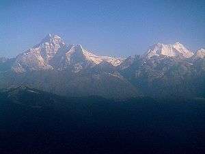 Gaurishankar (left) and Melungtse (right) | |
| Highest point | |
| Peak | Melungtse |
| Elevation | 7,181 m (23,560 ft) |
| Coordinates | 27°58′21″N 86°25′54″E / 27.97250°N 86.43167°E [1] |
| Geography | |
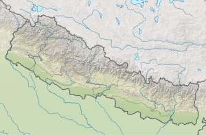 Location on Nepal / Tibet border | |
| Countries | Nepal and Tibet |
| District | Dolakha Town, Nepal |
| Range coordinates | 27°57′N 86°20′E / 27.950°N 86.333°ECoordinates: 27°57′N 86°20′E / 27.950°N 86.333°E |
| Parent range | Himalayas |
| Borders on | Mahalangur Himal |
Rolwāling Himāl (Nepali: रोल्वालिङ् हिमाल), (Rolwaling Valley), knows as a (Gaurishankar) rural municipality, is a section of the Himalayas in east-central Nepal along the Tibet border. [2] Rolwaling Himal includes Melungtse 7181m and Melungtse II 7023m inside Tibet and Gaurishankar 7134m on the Nepal border with some 50 additional peaks over 6000m, all extending from the Nangpa La pass where the Mahalangur section begins, southwest to the Tamakosi River. The Labuche Himal section rises beyond the Tamakosi to the northwest. Rolwaling Himal is bounded on the south by the Rolwaling Valley which contain several small sherpa's villages, the largest town in the area. It would take five to six days to reach Namche Bazaar after pass Tasilapcha. You also can trek to Everest base camp or you can trek to Lukla and fly to Kathmandu
Access to the valley and the mountains of the range is made on foot through an established trail system starting at Jagat, Bhiku rural municipality (230 km east of Kathmandu). 10 hours drive by local bus. A western style trek from Jagat to Beding will normally take four to five days. There are two ways to Beding, either by Tasinam village, beautiful hill (at 4500 m) or by Simigau. Tsho Rolpa (also Chho Rolpa) is one of the biggest glacial lakes in Nepal. The lake, which is located at an altitude of 4,580 metres (15,030 ft) in the Rolwaling Valley, Dolakha.
Rolwaling valley is under Gaurishankar Rural municipality, The first western exploration of the area was made by Eric Shipton in 1951 during the reconnaissance of Mount Everest.[3]
See also
- Mountain ranges of the Himalayas
- Geography of Nepal
- Geography of Tibet
- List of mountain ranges
References
- ↑ Eberhard Jurgalski. "High Asia II: Himalaya of Nepal, Bhutan, Sikkim and adjoining region of Tibet". Peaklist.org. Retrieved 16 November 2014.
- ↑ Carter, H. Adams (1985). "Classification of the Himalaya" (PDF). American Alpine Journal. American Alpine Club. 27 (59): 220–221. Retrieved 1 May 2011.
- ↑ Ward, Michael (1992). "The Exploration of the Nepalese Side of Everest" (PDF). Alpine Journal: 219–220. Retrieved 16 November 2014.