River Vyrnwy
River Vyrnwy (Afon Efyrnwy) | |
| River | |
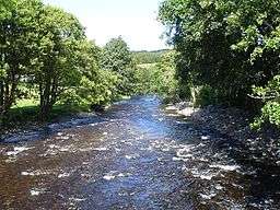 Vyrnwy near Pont Llogel | |
| Countries | Wales, England |
|---|---|
| Counties | Powys, Shropshire |
| Source | Lake Vyrnwy |
| Mouth | |
| - location | confluence with River Severn near Melverley |
| - coordinates | 52°44′11″N 2°59′48″W / 52.7363°N 2.9966°WCoordinates: 52°44′11″N 2°59′48″W / 52.7363°N 2.9966°W |
| Length | 40 mi (64 km) |
| Wikimedia Commons: River Vyrnwy | |
The River Vyrnwy (Welsh: Afon Efyrnwy, pronounced [ɛˈvərnʊɨ]) is a river which flows through northern Powys, Wales, and Shropshire, England. The name derives from Severn, the river of which it is a tributary.[1]
The river used to be sourced from the many rivers and streams running off the mountains surrounding the Vyrnwy valley. However, since the Lake Vyrnwy dam was built in the 1880s,[2] the river has flowed directly from the base of the dam.[3] The river runs for 39.7 miles (63.9 km),[4][5][6][7] and the last 8 miles (12.9 km) form part of the Welsh/English border between Powys and Shropshire. It eventually joins the River Severn near the village of Melverley.[8]
The river is paddled frequently by kayakers and canoeists, with the upper reaches of the river being predominantly Grade II white water with a few Grade III sections, most notably the Vyrnwy Gorge near the village of Dolanog. The other most prominent feature of the upper river is Dolanog Falls, a 20-foot-high (6 m) man-made weir that requires a portage by both kayaks and canoes.[9]
Much of the lower river below Pontrobert is Grade I and a good touring river due to being relatively placid when not in flood.[10]
References
- ↑ Ekwall, Eilert (1960). The concise Oxford dictionary of English place-names (4 ed.). Oxford: Clarendon Press. p. 489. ISBN 0-19-869103-3.
- ↑ "In praise of … Lake Vyrnwy". The Guardian. 21 July 2011. Retrieved 18 March 2017.
- ↑ "History of Lake Vyrnwy". www.lake-vyrnwy.com. Lake Vyrnwy tourism. Retrieved 18 March 2017.
- ↑ "Vrynwy - Lake Vrynwy to conf Afon Cownwy". environment.data.gov.uk. Environment Agency - Catchment Data Explorer. Retrieved 18 March 2017.
- ↑ "Afon Vyrnwy - conf Afon Cownwy to conf Afon Banwy". environment.data.gov.uk. Environment Agency - Catchment Data Explorer. Retrieved 18 March 2017.
- ↑ "Afon Vyrnwy DS of Banwy confluence". environment.data.gov.uk. Environment Agency - Catchment Data Explorer. Retrieved 18 March 2017.
- ↑ "Afon Vyrnwy - conf Afon Tanat to conf R Severn". environment.data.gov.uk. Environment Agency - Catchment Data Explorer. Retrieved 18 March 2017.
- ↑ "240" (Map). Oswestry. 1:25,000. Explorer. Ordnance Survey. 2015. ISBN 9780319244333.
- ↑ "River Vyrnwy - Pont Llogel to Pont Robert | North | Wales | Rivers - The UK Rivers Guidebook". www.ukriversguidebook.co.uk. Retrieved 19 March 2017.
- ↑ "Canoe Access to the river Vyrnwy". canoeaccess.co.uk. Retrieved 19 March 2017.
External links
| Unitary authorities | |
|---|---|
| Major settlements | |
| Rivers | |
| Canals | |
| Topics | |